1960s Maps of Lake City, Florida
Explore 2 historic maps of Lake City from the 1960s. These maps offer a rare glimpse into what life looked like during the 1960s — showing old roads, neighborhoods, homes, and landmarks that have changed or disappeared over time.
Whether you're researching your family's past, planning a metal detecting trip, or studying how Lake City's landscape evolved across the 1960s, these high-resolution maps are a powerful tool for exploring the history of this region.
- Focus on a specific era: All maps on this page are from the 1960s, giving you a focused view of this time period.
- See what’s changed: Compare century-old streets, trails, and buildings to today's modern landscape using overlays and satellite layers.
- Research with precision: Use these maps for genealogy, historical research, land use analysis, or educational projects.
- View, download, or print: Maps are fully viewable online in high resolution, and can be downloaded or printed for your own records.
Start exploring Lake City's history through authentic maps from the 1960s. This is your window into the past.
Lake City, FL maps
(2)- 1962 Map of Lake City East, 1964 Print
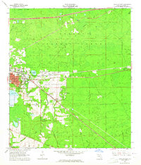 1962 Lake City East1964 Print · USGSColumbia County is shown here in the early sixties as it balanced forest industry with modern growth. Genealogists and historians can trace old community landmarks from Watertown to the Price Creek Cem and the early campus of Lake City Jr College.3 unique versions available
 - 1963 Map of Lake City West, 1965 Print
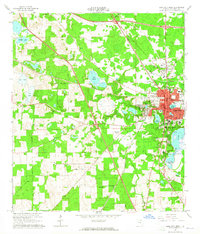 1963 Lake City West1965 Print · USGSLake City and the surrounding Columbia County landscape are shown in the early sixties as a vital railroad junction. Genealogists and historians can trace family locations near Mount Carmel Cemetery, Five Points School, or the Richardson High School campus.2 unique versions available
End of results
Showing maps 1-2 of 2
Top cities near Lake City
Frequently asked questions
- What are the different types of historical maps available for Lake City?
- What is the oldest map of Lake City?
- Where can I purchase historical maps of Lake City for my home or office?
- Where can I download high-res historical maps of Lake City?
- Are there historical topographic maps available for Lake City?
- Is there historical aerial imagery available for Lake City?
- Where are historical maps of Lake City sourced from?