
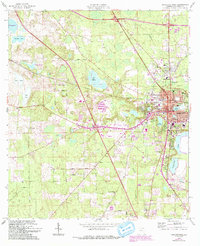
1963 Map of Lake City West
USGS Topo · Published 1965About this map
Lake City serves as a bustling hub in the early 1960s, defined by the convergence of the Seaboard Air Line, Georgia Southern and Florida, and Atlantic Coast Line railroads. This network supported a landscape of community-focused landmarks including the Columbia High School, the Courthouse, and the municipal Waterworks. The surrounding area is dotted with numerous small lakes such as Lake Jeffery, Lake Isabella, and the large Alligator Lake, which likely influenced local settlement and infrastructure patterns. Farther from the city center, the landscape transitions into a network of rural roads and established religious sites. Institutions like Mount Carmel Church and Hope Henry Church appear alongside their respective cemeteries, anchoring the small-scale communities of northern Florida. This survey captures a moment when traditional rail transportation still dictated the layout of the region's commerce and residential growth.
Find a feature on this map
65 named features on this map. Tap any name to fly to it.
Don’t see what you’re looking for? This feature index may not catch every label — zoom into the map to look around manually.
Map Details
Editions of this 1963 Lake City West Map
2 editions found
Other maps of this area

1954 · Valdosta
USGS Topo · 1:250,000

1958 · Valdosta
USGS Topo · 1:250,000

1959 · Valdosta
USGS Topo · 1:250,000

1961 · Deep Creek
USGS Topo · 1:24,000

1961 · White Springs East
USGS Topo · 1:24,000

1961 · White Springs West
USGS Topo · 1:24,000

1962 · Lake City East
USGS Topo · 1:24,000

1963 · Ellisville
USGS Topo · 1:24,000

1963 · Columbia
USGS Topo · 1:24,000
1969 · Wellborn
USGS Topo · 1:24,000