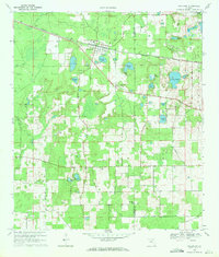
1969 Map of Wellborn
USGS Topo · Published 1971About this map
Wellborn serves as the central hub of this North Florida landscape, where the Seaboard Coast Line railroad dictates the orientation of the town's small street grid. The surrounding countryside is defined by an intricate network of sinkholes and ponds, including Grissom Hole, Classy Pond, and the larger Lake Ogden. The terrain's karst character is evident in the numerous depressions and isolated water bodies scattered across the Suwannee and Columbia county line.
Find a feature on this map
33 named features on this map. Tap any name to fly to it.
Don’t see what you’re looking for? This feature index may not catch every label — zoom into the map to look around manually.
Map Details
Editions of this 1969 Wellborn Map
This is the sole edition of this map. No revisions or reprints were ever made.
Other maps of this area

1954 · Valdosta
USGS Topo · 1:250,000

1958 · Valdosta
USGS Topo · 1:250,000

1959 · Valdosta
USGS Topo · 1:250,000

1961 · Live Oak East
USGS Topo · 1:24,000

1961 · White Springs East
USGS Topo · 1:24,000

1961 · White Springs West
USGS Topo · 1:24,000

1963 · Columbia
USGS Topo · 1:24,000

1963 · Lake City West
USGS Topo · 1:24,000
1969 · O'Brien
USGS Topo · 1:24,000
1969 · O'Brien SE
USGS Topo · 1:24,000