
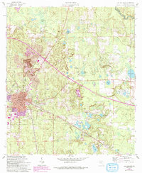
1961 Map of Live Oak East
USGS Topo · Published 1962About this map
Live Oak serves as a bustling North Florida hub in the early 1960s, defined by its complex web of rail infrastructure. The intersection of the Atlantic Coast Line, Seaboard Air Line Railroad, and Southern Railway underscores the city's role as a regional center for transport and commerce. Just north of the city limits, industrial activity is evident at the Suwannee Mine and its associated Quarry and Tailings Ponds, while the University of Florida Suwannee Valley Experiment Station points to the area's agricultural research importance.
Find a feature on this map
48 named features on this map. Tap any name to fly to it.
Don’t see what you’re looking for? This feature index may not catch every label — zoom into the map to look around manually.
Map Details
Editions of this 1961 Live Oak East Map
2 editions found
Other maps of this area

1954 · Valdosta
USGS Topo · 1:250,000

1955 · Mayo NE
USGS Topo · 1:24,000

1958 · Valdosta
USGS Topo · 1:250,000

1958 · Fort Union
USGS Topo · 1:24,000

1959 · Valdosta
USGS Topo · 1:250,000

1959 · Live Oak West
USGS Topo · 1:24,000

1961 · Hillcoat
USGS Topo · 1:24,000

1961 · White Springs West
USGS Topo · 1:24,000

1962 · Genoa
USGS Topo · 1:24,000
1969 · Wellborn
USGS Topo · 1:24,000