1900s (20th Century) Maps of Cross City, Florida
Explore 8 historic maps of Cross City from the 1900s (20th Century). These maps offer a rare glimpse into what life looked like during the 1900s — showing old roads, neighborhoods, homes, and landmarks that have changed or disappeared over time.
Whether you're researching your family's past, planning a metal detecting trip, or studying how Cross City's landscape evolved across the 1900s, these high-resolution maps are a powerful tool for exploring the history of this region.
- Focus on a specific era: All maps on this page are from the 1900s, giving you a focused view of this time period.
- See what’s changed: Compare century-old streets, trails, and buildings to today's modern landscape using overlays and satellite layers.
- Research with precision: Use these maps for genealogy, historical research, land use analysis, or educational projects.
- View, download, or print: Maps are fully viewable online in high resolution, and can be downloaded or printed for your own records.
Start exploring Cross City's history through authentic maps from the 1900s. This is your window into the past.
Cross City, FL maps
(8)- 1954 Map of Cross City West, 1955 Print
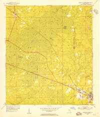 1954 Cross City West1955 Print · USGSDixie County at the start of the 1950s reveals a landscape defined by the timber industry and its expansive wetlands. Genealogists and local historians can trace the development of CROSS CITY, the community of Shamrock, and the rail infrastructure of the Atlantic Coast Line.3 unique versions available
 - 1954 Map of Eugene, 1955 Print
 1954 Eugene1955 Print · USGSCoastal Dixie County in the mid-fifties is defined by the deep reaches of California Swamp and the vital Atlantic Coast Line railroad. Genealogists and local historians can trace the rural landscape through Eugene, Long Pond Cem, and Prospect Ch.3 unique versions available
 - 1954 Map of Cross City East, 1955 Print
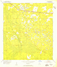
 1954 Cross City East1955 Print · USGSThe area around Cross City comes to life in the mid-1950s, showing a landscape defined by its wetlands and the Atlantic Coast Line railroad. You can trace the rural infrastructure from the Cross City Airport to local landmarks like Holly Hill Lookout Tower and Ocean Pond.3 unique versions available
 - 1954 Map of Cross City SW, 1955 Print
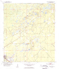
 1954 Cross City SW1955 Print · USGSCoastal Dixie County in the mid-1950s was a landscape of dense wetlands and forest management infrastructure. You can trace the remnants of the Old Railroad Grade or locate local landmarks like Sandhill Cem and the Horseshoe Lookout Tower.4 unique versions available
 - 1954 Map of Gainesville, 1965 Print
 1954 Gainesville1965 Print · USGSMid-century North Central Florida comes into focus as a landscape of timber, rails, and river towns along the Gulf. Trace family roots in established centers like Gainesville or follow the path of the Suwannee River to the coastal docks of Cedar Key.3 unique versions available
 - 1958 Map of Gainesville
 1958 Gainesville1958 Print · USGSNorth Central Florida’s rail and river networks are frozen in time just before the interstate era. Genealogists and historians can trace the paths of the Atlantic Coast Line through Gainesville or locate coastal settlements like Steinhatchee and Cedar Key.
 - 1959 Map of Gainesville
 1959 Gainesville1959 Print · USGSNorth Florida in the mid-fifties is seen here from the Gulf coast to the inland lakes, showing the rail-and-river network before modern highways dominated. Researchers can trace the paths of the Seaboard Air Line through towns like Chiefland and Micanopy, or explore the coastal inlets of Waccasassa Bay.
 - 1978 Map of Cross City, 1980 Print
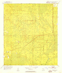
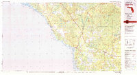 1978 Cross City1980 Print · USGSThe Florida Big Bend's coastal swamps and timberlands are captured here in the late seventies. Researchers can trace the path of the Seaboard Coast Line through Cross City or locate old coastal spots like Fishermans Rest and Clara.2 unique versions available
End of results
Showing maps 1-8 of 8
Top cities near Cross City
Frequently asked questions
- What are the different types of historical maps available for Cross City?
- What is the oldest map of Cross City?
- Where can I purchase historical maps of Cross City for my home or office?
- Where can I download high-res historical maps of Cross City?
- Are there historical topographic maps available for Cross City?
- Is there historical aerial imagery available for Cross City?
- Where are historical maps of Cross City sourced from?