Old Maps of Brent, Escambia County
Explore 29 old maps of Brent, spanning from 1920 to today. These high-resolution historic maps reveal how streets, neighborhoods, landmarks, and natural features evolved over time — perfect for genealogy, metal detecting, research, and local history exploration.
What you can do with these maps:
- See how Brent changed over time: Compare historical maps to modern-day views to trace roads, homesites, rail lines & more.
- View detailed metadata: Each map includes creators, publishers, year, scale, and archive source.
- Overlay maps with satellite & LiDAR: Visualize the past alongside modern tools to explore terrain & human change.
- Trusted historical sources: Maps sourced from the USGS, Library of Congress, and other archives.
- Access maps your way: View online, download high-res files, or order prints for personal or research use.
Start exploring old maps of Brent to uncover forgotten places, hidden landmarks, and the deep history beneath your feet.
Brent, Escambia County maps
(29)- 1920 Map of Milton
 1920 Milton1920 Print · USGSCovers Brent, including Pensacola, Milton, and other nearby areas
 - 1921 Map of Pensacola
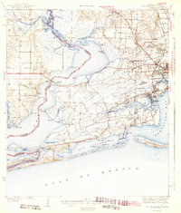
 1921 Pensacola1921 Print · USGSCovers Brent, including Pensacola, Tiger Point, and other nearby areas
 - 1921 Map of Fort Barrancas
 1921 Fort Barrancas1921 Print · USGSCovers Brent, including Pensacola, Lillian, and other nearby areas
 - 1921 Map of Muscogee
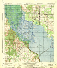
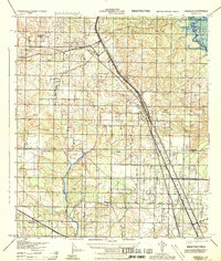
 1921 Muscogee1921 Print · USGSCovers Brent, including Ensley, Molino, and other nearby areas
 - 1941 Map of Fort Barrancas
 1941 Fort Barrancas1941 Print · USGSCovers Brent, including Pensacola, Lillian, and other nearby areas3 unique versions available
 - 1941 Map of Muscogee, 1956 Print
 1941 Muscogee1956 Print · USGSCovers Brent, including Ensley, Molino, and other nearby areas3 unique versions available
 - 1941 Map of Pensacola, 1956 Print
 1941 Pensacola1956 Print · USGSCovers Brent, including Pensacola, Tiger Point, and other nearby areas
 - 1941 Map of Milton, 1956 Print
 1941 Milton1956 Print · USGSCovers Brent, including Pensacola, Milton, and other nearby areas2 unique versions available
 - 1942 Map of Pensacola
 1942 Pensacola1942 Print · USGSCovers Brent, including Pensacola, Tiger Point, and other nearby areas2 unique versions available
 - 1943 Map of Muscogee
 1943 Muscogee1943 Print · USGSCovers Brent, including Ensley, Molino, and other nearby areas2 unique versions available
 - 1943 Map of Fort Barrancas
 1943 Fort Barrancas1943 Print · USGSCovers Brent, including Pensacola, Lillian, and other nearby areas3 unique versions available
 - 1943 Map of Milton
 1943 Milton1943 Print · USGSCovers Brent, including Pensacola, Milton, and other nearby areas2 unique versions available
 - 1944 Map of Floridatown
 1944 Floridatown1944 Print · USGSCovers Brent, including Pensacola, Floridatown, and other nearby areas
 - 1944 Map of West Pensacola
 1944 West Pensacola1944 Print · USGSCovers Brent, including Pensacola, Myrtle Grove, and other nearby areas
 - 1944 Map of Gonzalez
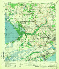
 1944 Gonzalez1944 Print · USGSCovers Brent, including Ensley, Gonzalez, and other nearby areas
 - 1944 Map of Pensacola
 1944 Pensacola1944 Print · USGSCovers Brent, including Pensacola, East Pensacola Heights, and other nearby areas
 - 1957 Map of Pensacola, 1967 Print
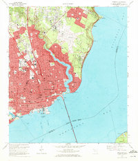
 1957 Pensacola1967 Print · USGSCovers Brent, including Mobile, Pensacola, and other nearby areas3 unique versions available
 - 1959 Map of Pensacola
 1959 Pensacola1959 Print · USGSCovers Brent, including Mobile, Pensacola, and other nearby areas
 - 1960 Map of Pensacola
 1960 Pensacola1960 Print · USGSCovers Brent, including Mobile, Pensacola, and other nearby areas
 - 1970 Map of Pensacola, 1972 Print
 1970 Pensacola1972 Print · USGSCovers Brent, including Pensacola, East Pensacola Heights, and other nearby areas3 unique versions available
 - 1970 Map of West Pensacola, 1972 Print
 1970 West Pensacola1972 Print · USGSCovers Brent, including Pensacola, Myrtle Grove, and other nearby areas2 unique versions available
 - 1978 Map of Pace
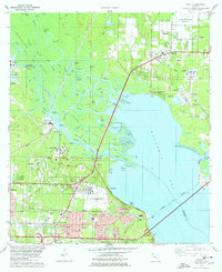 1978 Pace1978 Print · USGSCovers Brent, including Pensacola, Floridatown, and other nearby areas3 unique versions available
 - 1978 Map of Cantonment
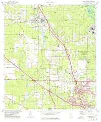 1978 Cantonment1978 Print · USGSCovers Brent, including Ensley, Gonzalez, and other nearby areas3 unique versions available
 - 1978 Map of Pensacola, 1980 Print
 1978 Pensacola1980 Print · USGSCovers Brent, including Pensacola, Fairhope, and other nearby areas3 unique versions available
 - 1981 Map of Bay Minette
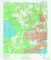
 1981 Bay Minette1981 Print · USGSCovers Brent, including Mobile, Pensacola, and other nearby areas2 unique versions available
Showing maps 1-25 of 29
Frequently asked questions
- What are the different types of historical maps available for Brent?
- What is the oldest map of Brent?
- Where can I purchase historical maps of Brent for my home or office?
- Where can I download high-res historical maps of Brent?
- Are there historical topographic maps available for Brent?
- Is there historical aerial imagery available for Brent?
- Where are historical maps of Brent sourced from?