Old Maps of Brent, Escambia County for Metal Detecting
Plan your next treasure hunt with 29 historic maps of Brent. Find old homesites, ghost towns, trails, and gathering spots that may be lost to time — perfect for identifying promising metal detecting locations.
- Locate forgotten sites: Uncover places like long-lost settlements, abandoned rail lines, or gathering spots.
- Plan better hunts: Use map overlays combined with LiDAR or satellite views to narrow in on historically rich areas.
- Made for detectorists: Thousands of hobbyists use these maps to discover relics, coins, and hidden history.
Use these historic maps to boost your research and find new opportunities beneath the surface of Brent.
Brent, Escambia County maps
(29)- 1920 Map of Milton
 1920 Milton1920 Print · USGSCovers Brent, including Pensacola, Milton, and other nearby areas
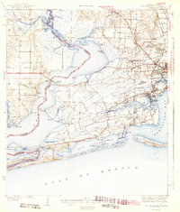
 - 1921 Map of Pensacola
 1921 Pensacola1921 Print · USGSCovers Brent, including Pensacola, Tiger Point, and other nearby areas
 - 1921 Map of Fort Barrancas
 1921 Fort Barrancas1921 Print · USGSCovers Brent, including Pensacola, Lillian, and other nearby areas
 - 1921 Map of Muscogee
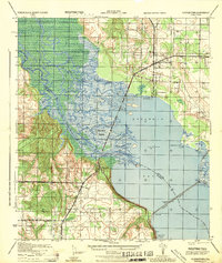
 1921 Muscogee1921 Print · USGSCovers Brent, including Ensley, Molino, and other nearby areas
 - 1941 Map of Fort Barrancas
 1941 Fort Barrancas1941 Print · USGSCovers Brent, including Pensacola, Lillian, and other nearby areas3 unique versions available
 - 1941 Map of Muscogee, 1956 Print
 1941 Muscogee1956 Print · USGSCovers Brent, including Ensley, Molino, and other nearby areas3 unique versions available
 - 1941 Map of Pensacola, 1956 Print
 1941 Pensacola1956 Print · USGSCovers Brent, including Pensacola, Tiger Point, and other nearby areas
 - 1941 Map of Milton, 1956 Print
 1941 Milton1956 Print · USGSCovers Brent, including Pensacola, Milton, and other nearby areas2 unique versions available
 - 1942 Map of Pensacola
 1942 Pensacola1942 Print · USGSCovers Brent, including Pensacola, Tiger Point, and other nearby areas2 unique versions available
 - 1943 Map of Muscogee
 1943 Muscogee1943 Print · USGSCovers Brent, including Ensley, Molino, and other nearby areas2 unique versions available
 - 1943 Map of Fort Barrancas
 1943 Fort Barrancas1943 Print · USGSCovers Brent, including Pensacola, Lillian, and other nearby areas3 unique versions available
 - 1943 Map of Milton
 1943 Milton1943 Print · USGSCovers Brent, including Pensacola, Milton, and other nearby areas2 unique versions available
 - 1944 Map of Floridatown
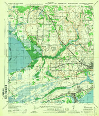
 1944 Floridatown1944 Print · USGSCovers Brent, including Pensacola, Floridatown, and other nearby areas
 - 1944 Map of West Pensacola
 1944 West Pensacola1944 Print · USGSCovers Brent, including Pensacola, Myrtle Grove, and other nearby areas
 - 1944 Map of Gonzalez
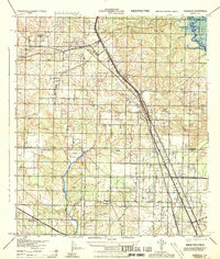 1944 Gonzalez1944 Print · USGSCovers Brent, including Ensley, Gonzalez, and other nearby areas
 - 1944 Map of Pensacola
 1944 Pensacola1944 Print · USGSCovers Brent, including Pensacola, East Pensacola Heights, and other nearby areas
 - 1957 Map of Pensacola, 1967 Print
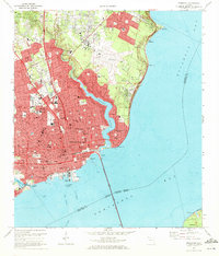
 1957 Pensacola1967 Print · USGSCovers Brent, including Mobile, Pensacola, and other nearby areas3 unique versions available
 - 1959 Map of Pensacola
 1959 Pensacola1959 Print · USGSCovers Brent, including Mobile, Pensacola, and other nearby areas
 - 1960 Map of Pensacola
 1960 Pensacola1960 Print · USGSCovers Brent, including Mobile, Pensacola, and other nearby areas
 - 1970 Map of Pensacola, 1972 Print
 1970 Pensacola1972 Print · USGSCovers Brent, including Pensacola, East Pensacola Heights, and other nearby areas3 unique versions available
 - 1970 Map of West Pensacola, 1972 Print
 1970 West Pensacola1972 Print · USGSCovers Brent, including Pensacola, Myrtle Grove, and other nearby areas2 unique versions available
 - 1978 Map of Pace
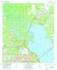 1978 Pace1978 Print · USGSCovers Brent, including Pensacola, Floridatown, and other nearby areas3 unique versions available
 - 1978 Map of Cantonment
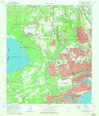
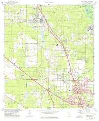 1978 Cantonment1978 Print · USGSCovers Brent, including Ensley, Gonzalez, and other nearby areas3 unique versions available
 - 1978 Map of Pensacola, 1980 Print
 1978 Pensacola1980 Print · USGSCovers Brent, including Pensacola, Fairhope, and other nearby areas3 unique versions available
 - 1981 Map of Bay Minette
 1981 Bay Minette1981 Print · USGSCovers Brent, including Mobile, Pensacola, and other nearby areas2 unique versions available
Showing maps 1-25 of 29
Frequently asked questions
- What are the different types of historical maps available for Brent?
- What is the oldest map of Brent?
- Where can I purchase historical maps of Brent for my home or office?
- Where can I download high-res historical maps of Brent?
- Are there historical topographic maps available for Brent?
- Is there historical aerial imagery available for Brent?
- Where are historical maps of Brent sourced from?