1970s Maps of Century, Florida
Explore 2 historic maps of Century from the 1970s. These maps offer a rare glimpse into what life looked like during the 1970s — showing old roads, neighborhoods, homes, and landmarks that have changed or disappeared over time.
Whether you're researching your family's past, planning a metal detecting trip, or studying how Century's landscape evolved across the 1970s, these high-resolution maps are a powerful tool for exploring the history of this region.
- Focus on a specific era: All maps on this page are from the 1970s, giving you a focused view of this time period.
- See what’s changed: Compare century-old streets, trails, and buildings to today's modern landscape using overlays and satellite layers.
- Research with precision: Use these maps for genealogy, historical research, land use analysis, or educational projects.
- View, download, or print: Maps are fully viewable online in high resolution, and can be downloaded or printed for your own records.
Start exploring Century's history through authentic maps from the 1970s. This is your window into the past.
Century, FL maps
(2)- 1978 Map of Jay
 1978 Jay1978 Print · USGSThe Jay area of Santa Rosa County was a bustling center of energy production and river-bottom agriculture in the late seventies. Researchers can trace rural family roots through landmarks like McCostill Cem, Ebenezer Ch, and the extensive Oil Field.4 unique versions available
 - 1978 Map of Century
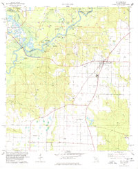
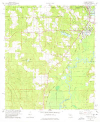 1978 Century1978 Print · USGSThe Florida-Alabama state line and the winding Escambia River define this region in the late seventies. Researchers can trace family history through sites like Carney Cem, Byrneville Ch, and the old Louisville and Nashville rail lines.
End of results
Showing maps 1-2 of 2
Top cities near Century
- Atmore historical maps
- Brewton historical maps
- East Brewton historical maps
- Flomaton historical maps
- McDavid historical maps
- Jay historical maps
See more
Top neighborhoods of Century
Frequently asked questions
- What are the different types of historical maps available for Century?
- What is the oldest map of Century?
- Where can I purchase historical maps of Century for my home or office?
- Where can I download high-res historical maps of Century?
- Are there historical topographic maps available for Century?
- Is there historical aerial imagery available for Century?
- Where are historical maps of Century sourced from?