1950s Maps of Carrollwood, Florida
Explore 5 historic maps of Carrollwood from the 1950s. These maps offer a rare glimpse into what life looked like during the 1950s — showing old roads, neighborhoods, homes, and landmarks that have changed or disappeared over time.
Whether you're researching your family's past, planning a metal detecting trip, or studying how Carrollwood's landscape evolved across the 1950s, these high-resolution maps are a powerful tool for exploring the history of this region.
- Focus on a specific era: All maps on this page are from the 1950s, giving you a focused view of this time period.
- See what’s changed: Compare century-old streets, trails, and buildings to today's modern landscape using overlays and satellite layers.
- Research with precision: Use these maps for genealogy, historical research, land use analysis, or educational projects.
- View, download, or print: Maps are fully viewable online in high resolution, and can be downloaded or printed for your own records.
Start exploring Carrollwood's history through authentic maps from the 1950s. This is your window into the past.
Carrollwood, FL maps
(5)- 1955 Map of Plant City, 1966 Print
 1955 Plant City1966 Print · USGSMid-century Central Florida comes to life in this survey of the Nature Coast and the inland citrus and rail belt. Genealogists and historians can trace the paths of the Atlantic Coast Line, locate the Anclote Keys Lighthouse, or find old communities like Masaryktown and Lacoochee.6 unique versions available
 - 1956 Map of Sulphur Springs, 1957 Print
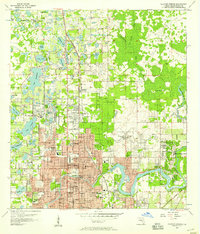 1956 Sulphur Springs1957 Print · USGSHillsborough County transitions from rural hammocks to suburban expansion in the mid-fifties as the Tampa area grows northward. Researchers can trace family history through sites like Lake Magdalene Ch, Nowatney, and the abandoned Henderson Hillsborough International Airport.4 unique versions available
 - 1956 Map of Citrus Park, 1957 Print
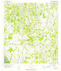 1956 Citrus Park1957 Print · USGSHillsborough County in the mid-1950s was a landscape of citrus groves and scattered settlements connected by the Seaboard Air Line. Genealogists and historians can trace the early footprints of Citrus Park, Mullis City, and the rural community at Cosme.5 unique versions available
 - 1958 Map of Plant City
 1958 Plant City1958 Print · USGSFlorida's Gulf Coast and inland ridge country are captured here in the mid-fifties, showing the region before modern sprawl. Genealogists and historians can trace rail-era towns like Richland and Trilby or locate coastal landmarks such as the Anclote Keys Lighthouse.
 - 1959 Map of Plant City
 1959 Plant City1959 Print · USGSThe West Florida coast and inland timberlands are captured here in the late fifties, from the bend of the Gulf to the rail hubs of the interior. Trace the paths of the Atlantic Coast Line through Inverness and find landmarks like the Anclote Keys Lighthouse.
End of results
Showing maps 1-5 of 5
Top cities near Carrollwood
- Tampa historical maps
- Saint Petersburg historical maps
- Clearwater historical maps
- Largo historical maps
- Riverview historical maps
- Pinellas Park historical maps
See more
Top neighborhoods of Carrollwood
- Andover historical maps
- Andover Village historical maps
- Mullis City historical maps
- Carrollwood historical maps
- Goldstein historical maps
- Carrollwood Village historical maps
Frequently asked questions
- What are the different types of historical maps available for Carrollwood?
- What is the oldest map of Carrollwood?
- Where can I purchase historical maps of Carrollwood for my home or office?
- Where can I download high-res historical maps of Carrollwood?
- Are there historical topographic maps available for Carrollwood?
- Is there historical aerial imagery available for Carrollwood?
- Where are historical maps of Carrollwood sourced from?