1940s Maps of East Lake-Orient Park, Florida
Explore 3 historic maps of East Lake-Orient Park from the 1940s. These maps offer a rare glimpse into what life looked like during the 1940s — showing old roads, neighborhoods, homes, and landmarks that have changed or disappeared over time.
Whether you're researching your family's past, planning a metal detecting trip, or studying how East Lake-Orient Park's landscape evolved across the 1940s, these high-resolution maps are a powerful tool for exploring the history of this region.
- Focus on a specific era: All maps on this page are from the 1940s, giving you a focused view of this time period.
- See what’s changed: Compare century-old streets, trails, and buildings to today's modern landscape using overlays and satellite layers.
- Research with precision: Use these maps for genealogy, historical research, land use analysis, or educational projects.
- View, download, or print: Maps are fully viewable online in high resolution, and can be downloaded or printed for your own records.
Start exploring East Lake-Orient Park's history through authentic maps from the 1940s. This is your window into the past.
East Lake-Orient Park, FL maps
(3)- 1944 Map of Mango
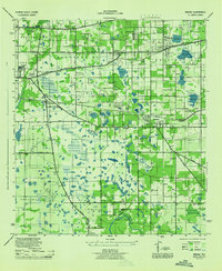 1944 Mango1944 Print · USGSHillsborough County's interior settlements and agricultural lands are captured here during the mid-forties. Researchers can trace family history through sites like St Marys Ch and Cem, the Levin Armwood School, and the early rail stops at Seffner and Mango.
 - 1944 Map of Tampa
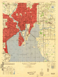
 1944 Tampa1944 Print · USGSTampa and the surrounding bayfront neighborhoods are shown during the mid-forties, capturing the city's transition into a modern maritime hub. Trace historical property lines and landmarks like Ybor City, Davis Islands, and the Peter O Knight Municipal Airport.
 - 1947 Map of Tampa
 1947 Tampa1947 Print · USGSTampa and its harbor districts appear here in the late Forties as the city's rail and maritime industries reached a mid-century peak. Genealogists and historians can trace the old street grids of Ybor City, locate family plots in Rose Hill Cem, and see early aviation at Peter O Knight Municipal Airport.2 unique versions available
End of results
Showing maps 1-3 of 3
Top cities near East Lake-Orient Park
- Tampa historical maps
- Saint Petersburg historical maps
- Brandon historical maps
- Riverview historical maps
- Temple Terrace historical maps
- Lutz historical maps
See more
Top neighborhoods of East Lake-Orient Park
- East Lake Park historical maps
- Amber Place historical maps
- East Lake historical maps
- Orient Park historical maps
Frequently asked questions
- What are the different types of historical maps available for East Lake-Orient Park?
- What is the oldest map of East Lake-Orient Park?
- Where can I purchase historical maps of East Lake-Orient Park for my home or office?
- Where can I download high-res historical maps of East Lake-Orient Park?
- Are there historical topographic maps available for East Lake-Orient Park?
- Is there historical aerial imagery available for East Lake-Orient Park?
- Where are historical maps of East Lake-Orient Park sourced from?