1990s Maps of East Lake-Orient Park, Florida
Explore 2 historic maps of East Lake-Orient Park from the 1990s. These maps offer a rare glimpse into what life looked like during the 1990s — showing old roads, neighborhoods, homes, and landmarks that have changed or disappeared over time.
Whether you're researching your family's past, planning a metal detecting trip, or studying how East Lake-Orient Park's landscape evolved across the 1990s, these high-resolution maps are a powerful tool for exploring the history of this region.
- Focus on a specific era: All maps on this page are from the 1990s, giving you a focused view of this time period.
- See what’s changed: Compare century-old streets, trails, and buildings to today's modern landscape using overlays and satellite layers.
- Research with precision: Use these maps for genealogy, historical research, land use analysis, or educational projects.
- View, download, or print: Maps are fully viewable online in high resolution, and can be downloaded or printed for your own records.
Start exploring East Lake-Orient Park's history through authentic maps from the 1990s. This is your window into the past.
East Lake-Orient Park, FL maps
(2)- 1995 Map of Tampa, 1999 Print
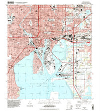 1995 Tampa1999 Print · USGSTampa's maritime and industrial landscape is captured here during the mid-nineties, showing a city deeply tied to its waterfront and rail lines. You can trace the development of Ybor City, locate numerous historic burial grounds like Myrtle Hill Cemetery, and explore the rail operations at Uceta Yard.
 - 1999 Map of Brandon, 2002 Print
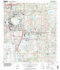 1999 Brandon2002 Print · USGSSuburban development surrounds the historic settlements of Brandon and Valrico during the late nineties as the region matured into a major residential hub. Researchers can trace local heritage at Hackney Cem, find the namesake waters of Mango Lake, or locate schools like Brandon Sr High School.
End of results
Showing maps 1-2 of 2
Top cities near East Lake-Orient Park
- Tampa historical maps
- Saint Petersburg historical maps
- Brandon historical maps
- Riverview historical maps
- Temple Terrace historical maps
- Lutz historical maps
See more
Top neighborhoods of East Lake-Orient Park
- East Lake Park historical maps
- Amber Place historical maps
- East Lake historical maps
- Orient Park historical maps
Frequently asked questions
- What are the different types of historical maps available for East Lake-Orient Park?
- What is the oldest map of East Lake-Orient Park?
- Where can I purchase historical maps of East Lake-Orient Park for my home or office?
- Where can I download high-res historical maps of East Lake-Orient Park?
- Are there historical topographic maps available for East Lake-Orient Park?
- Is there historical aerial imagery available for East Lake-Orient Park?
- Where are historical maps of East Lake-Orient Park sourced from?