1960s Maps of Levy County, Florida
Explore 8 historic maps of Levy County from the 1960s. These maps offer a rare glimpse into what life looked like during the 1960s — showing old roads, neighborhoods, homes, and landmarks that have changed or disappeared over time.
Whether you're researching your family's past, planning a metal detecting trip, or studying how Levy County's landscape evolved across the 1960s, these high-resolution maps are a powerful tool for exploring the history of this region.
- Focus on a specific era: All maps on this page are from the 1960s, giving you a focused view of this time period.
- See what’s changed: Compare century-old streets, trails, and buildings to today's modern landscape using overlays and satellite layers.
- Research with precision: Use these maps for genealogy, historical research, land use analysis, or educational projects.
- View, download, or print: Maps are fully viewable online in high resolution, and can be downloaded or printed for your own records.
Start exploring Levy County's history through authentic maps from the 1960s. This is your window into the past.
Levy County, FL maps
(8)- 1964 Map of Plant City
 1964 Plant City1964 Print · USGSThe West Florida coast and its interior rail corridors come alive in this mid-sixties survey, spanning from the gulf marshes to the agricultural heartland. Researchers can trace the routes of the Atlantic Coast Line through settlements like Bushnell, Inverness, and Plant City.
 - 1968 Map of Lebanon Station
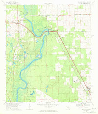
 1968 Lebanon Station1968 Print · USGSLevy County's coastal lowlands are captured here in the late sixties, where the timber and rail economy met the swamp. Researchers can trace family-named river landings like Peeks Landing or locate rural landmarks such as Mt Erie Ch and the Lebanon Lookout Tower.
 - 1968 Map of Newberry SW, 1969 Print
 1968 Newberry SW1969 Print · USGSThe swampy lowlands of the Levy and Gilchrist county line are documented here in the late sixties, showing a landscape defined by springs and ponds. Genealogists and historians can locate the Fort Waccasassa Site, Ebenezer Ch, and family landmarks like Asbell Creek Bridge.2 unique versions available
 - 1968 Map of Archer, 1970 Print
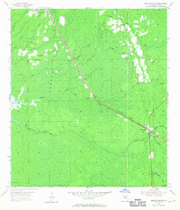
 1968 Archer1970 Print · USGSArcher and its surrounding pond country are captured here in the late sixties as the local rail and agricultural economy persisted. Researchers can locate family landmarks like Laurel Hill Cem, the Archer Community Sch, and old community nodes at Pinesville.3 unique versions available
 - 1968 Map of Trenton, 1971 Print
 1968 Trenton1971 Print · USGSThe rural interior of Gilchrist County comes into focus during the late sixties, centered on the rail-side settlement of Trenton. Researchers can trace the Seaboard Coast Line tracks and the specific grid of the town center as it stood before modern growth.3 unique versions available
 - 1968 Map of Suwannee River, 1971 Print
 1968 Suwannee River1971 Print · USGSThe Florida river country comes alive in this survey of the tri-county borderlands during the late sixties. Genealogists and local historians can trace the foundations of Old Town and Fanning Springs, or locate rural landmarks like St Christophers Ch and the Old Town Cem.3 unique versions available
 - 1969 Map of Williston, 1971 Print
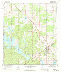
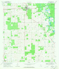
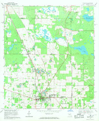 1969 Williston1971 Print · USGSFlorida's limestone country and the rail corridors of Levy County are documented here in the late sixties. Genealogists and researchers can locate several rural churches and burial grounds like New Hope Cem, the Orange Hill Cem, and St Josephs Ch.2 unique versions available
 - 1969 Map of Morriston, 1971 Print
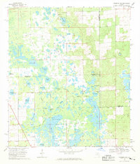
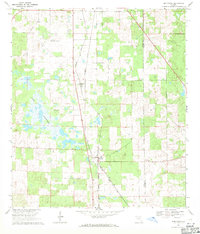 1969 Morriston1971 Print · USGSLevy County at the end of the sixties shows a landscape of rail-side settlements and karst lakes. Trace the tracks of the Seaboard Coast Line through Montbrook and Morriston, or locate family burial sites at Plummers Cem and Pleasant Hill Cem.3 unique versions available
End of results
Showing maps 1-8 of 8
Top cities of Levy County
- Williston historical maps
- Chiefland historical maps
- East Bronson historical maps
- Inglis historical maps
- Bronson historical maps
- Cedar Key historical maps
See more
Frequently asked questions
- What are the different types of historical maps available for Levy County?
- What is the oldest map of Levy County?
- Where can I purchase historical maps of Levy County for my home or office?
- Where can I download high-res historical maps of Levy County?
- Are there historical topographic maps available for Levy County?
- Is there historical aerial imagery available for Levy County?
- Where are historical maps of Levy County sourced from?