
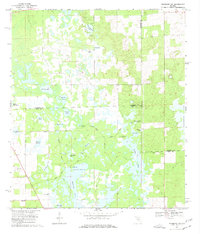
1968 Map of Newberry SW
USGS Topo · Published 1969About this map
Fort Waccasassa Site serves as a historical anchor in this wetland-rich landscape where the borders of Gilchrist, Alachua, and Levy Counties converge. The terrain is defined by a dense network of hydrologic features, including the Waccasassa River, Sawgrass Springs, and the massive Watermelon Pond to the east. Small communities like Haven and Winquipin are positioned near Winquipin Lake, while Ebenezer Ch stands as a focal point for the local rural community.
Find a feature on this map
37 named features on this map. Tap any name to fly to it.
Don’t see what you’re looking for? This feature index may not catch every label — zoom into the map to look around manually.
Map Details
Editions of this 1968 Newberry SW Map
2 editions found
Other maps of this area

1954 · Chiefland
USGS Topo · 1:24,000

1954 · Bronson
USGS Topo · 1:24,000

1954 · Gainesville
USGS Topo · 1:250,000

1955 · Bronson NE
USGS Topo · 1:24,000

1958 · Gainesville
USGS Topo · 1:250,000

1959 · Gainesville
USGS Topo · 1:250,000

1968 · Waters Lake
USGS Topo · 1:24,000
1968 · Archer
USGS Topo · 1:24,000

1968 · Newberry
USGS Topo · 1:24,000

1968 · Fourmile Lake
USGS Topo · 1:24,000