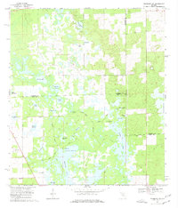
1968 Map of Newberry SW
USGS Topo · Published 1977About this map
The Fort Waccasassa Site sits at the heart of this hydrologically complex landscape where the boundaries of Levy, Gilchrist, and Alachua counties converge. Mapped in the late 1960s, the terrain is defined by a dense network of lakes, ponds, and prairie wetlands, including the expansive Watermelon Pond and the headwaters of the Waccasassa River. The map captures the quiet rural character of the era, marked by isolated settlements like Shelley and social anchors such as Ebenezer Ch and Union Ch.
Find a feature on this map
38 named features on this map. Tap any name to fly to it.
Don’t see what you’re looking for? This feature index may not catch every label — zoom into the map to look around manually.
Map Details
Editions of this 1968 Newberry SW Map
2 editions found
Other maps of this area

1954 · Chiefland
USGS Topo · 1:24,000

1954 · Bronson
USGS Topo · 1:24,000

1954 · Gainesville
USGS Topo · 1:250,000

1955 · Bronson NE
USGS Topo · 1:24,000

1958 · Gainesville
USGS Topo · 1:250,000

1959 · Gainesville
USGS Topo · 1:250,000

1968 · Newberry SW
USGS Topo · 1:24,000

1968 · Waters Lake
USGS Topo · 1:24,000
1968 · Archer
USGS Topo · 1:24,000

1968 · Newberry
USGS Topo · 1:24,000