Old Maps of Madison County, Florida for Genealogy
Trace your family roots with 128 historic maps of Madison County. These high-res maps reveal old neighborhoods, homesites, landmarks, and streets — helping you uncover where your ancestors lived and how the area evolved over time.
- Explore historic neighborhoods: Identify where your relatives may have lived in the 1800s or 1900s.
- Compare maps over time: Trace the changes in streets, buildings, and landmarks for multi-generational research.
- Perfect for genealogy & ancestry research: Used by family historians and researchers to map out lineage and migration.
These maps are an incredible resource for exploring your personal connection to Madison County's past.
Madison County, FL maps
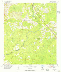
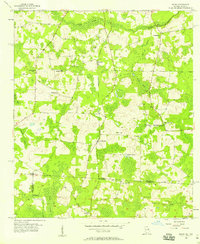
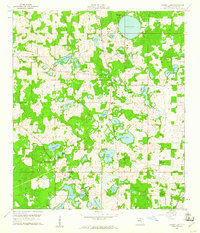
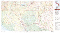
(128)- 1954 Map of Greenville, 1956 Print
 1954 Greenville1956 Print · USGSThe Madison and Jefferson County line in the mid-1950s shows a landscape of timber tracts and rail-junction towns. Researchers can trace rural lineages through numerous local landmarks like New Hopewell Ch, Barclay Cem, and the Seaboard Air Line tracks.3 unique versions available
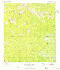
 - 1954 Map of Greenville NE, 1956 Print
 1954 Greenville NE1956 Print · USGSMadison County's wet timberlands and rural crossroads are captured here in the mid-fifties, just as aerial photography began to refine local mapping. Genealogists and historians can trace community sites like Concord Ch, the Cross Road Sch, and the long-established Evergreen Cem.2 unique versions available
 - 1954 Map of Valdosta, 1967 Print
 1954 Valdosta1967 Print · USGSThe South Georgia and North Florida borderlands are captured here in the mid-fifties, showing the deep timber and wetland networks of the coastal plain. Researchers can trace the path of the Atlantic Coast Line through Valdosta or explore the interior of the Okefenokee Swamp.2 unique versions available
 - 1955 Map of Lamont, 1956 Print
 1955 Lamont1956 Print · USGSJefferson County rural life in the mid-fifties is captured here, centered on the settlements of Aucilla and Lamont. Researchers can locate family landmarks like Turkey Scratch Church, Scruggs Cemetery, and the Seaboard Air Line railroad.3 unique versions available
 - 1955 Map of Shady Grove, 1956 Print
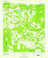
 1955 Shady Grove1956 Print · USGSMadison and Taylor counties in the mid-1950s reveal a landscape of timber-dependent rail stops and rural homesteads. Genealogists can locate family landmarks like Tuten Cemetery, Pleasant Grove Church, and the community of Eridu.4 unique versions available
 - 1955 Map of Lamont SE, 1956 Print
 1955 Lamont SE1956 Print · USGSThe Aucilla River basin in the mid-1950s reveals a rural landscape defined by small river settlements and forest industry. Genealogists can trace family footprints at Walker Cem, Allison Sch, and the remote community of Eridu along the railroad.4 unique versions available
 - 1955 Map of Greenville SE, 1956 Print
 1955 Greenville SE1956 Print · USGSMadison and Taylor counties are captured here in the mid-fifties, showing a rural Florida landscape defined by timber tracts and wetlands. Researchers can trace family roots at Moseley Hall, Bailey Cem, and the church at Wigginsville Ch.3 unique versions available
 - 1956 Map of Clyattville, 1957 Print
 1956 Clyattville1957 Print · USGSThe Georgia-Florida border country comes into focus in the mid-fifties, centered on the railroad town of Clyattville. Genealogists can trace family roots at Forest Grove Cem and numerous rural houses of worship like Benevolence Ch.3 unique versions available
 - 1956 Map of Nankin, 1957 Print
 1956 Nankin1957 Print · USGSGeorgia's border with Florida in the mid-fifties is defined by the winding Withlacoochee River and a landscape of rural congregations. Genealogists can trace family roots through numerous sites like Redland Cem, Antioch Ch, and the settlement of Nankin.2 unique versions available
 - 1956 Map of Baden, 1958 Print
 1956 Baden1958 Print · USGSThe Georgia-Florida borderlands come to life in the mid-1950s, showing the rural communities and railroad stops along the SOUTHERN line. Researchers can trace family roots at Radford-Denson Cem, Hickory Head Ch, and local schoolhouses like Liberty Sch.2 unique versions available
 - 1956 Map of Octahatchee, 1958 Print
 1956 Octahatchee1958 Print · USGSThe Florida-Georgia borderlands near the mid-century were a landscape of cypress swamps and quiet rural outposts. Genealogists can locate family landmarks like McCall Cem and Blair Cem or trace the community around Bellville High Sch and Triumph Ch.2 unique versions available
 - 1958 Map of Valdosta
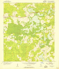
 1958 Valdosta1958 Print · USGSSouth Georgia and North Florida are captured here in the mid-fifties, showing the vast Okefenokee Swamp and the vital timber and rail corridors connecting the two states. Researchers can locate the footprint of Moody Air Force Base, trace the Live Oak Perry and Gulf railroad, or find early community sites like Bakers Mill and Paradise Church.
 - 1958 Map of Madison SW, 1959 Print
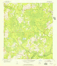
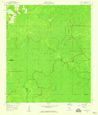 1958 Madison SW1959 Print · USGSMadison and Taylor Counties are captured in the late 1950s, showing a landscape almost entirely defined by the wetlands of San Pedro Bay. Researchers can trace the boundary between the two counties and locate the New Oakland Ch and the Sinclair Lookout tower.2 unique versions available
 - 1958 Map of Madison SE, 1959 Print
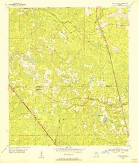
 1958 Madison SE1959 Print · USGSMadison and Lafayette counties in the late fifties show a landscape of karst ponds and scattered rural congregations. Genealogists and local historians can locate Midway Ch, the riverfront at the Suwannee River, and landmarks like Tenmile Pond.3 unique versions available
 - 1958 Map of Lee, 1960 Print
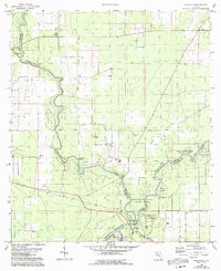
 1958 Lee1960 Print · USGSMadison County's railroad and farming culture is well-established in the late fifties as the timber industry shapes the local landscape. Genealogists can trace family landmarks and rural life through Corinth Ch, Stonewall Cem, and the sinkhole-dotted terrain near Lee.3 unique versions available
 - 1959 Map of Valdosta
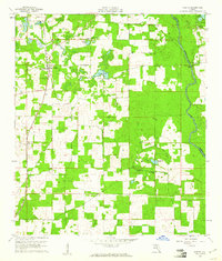
 1959 Valdosta1959 Print · USGSThe Georgia-Florida borderlands in the mid-fifties reveal a landscape of massive blackwater swamps and emerging military aviation hubs. Genealogists and historians can trace rail-stop towns like Fargo and Stockton or explore the interior reaches of the Okefenokee Swamp and Billys Island.
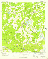
 - 1959 Map of Madison
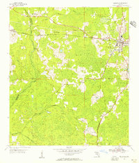
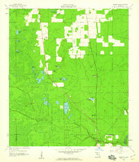
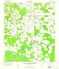
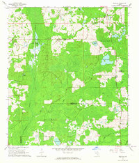
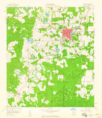 1959 Madison1959 Print · USGSMadison and its surrounding North Florida wetlands are captured in the late fifties, showcasing a growing regional center at a transit crossroads. Genealogists and researchers can locate North Florida Junior College, tracing local family names through sites like St Lukes Ch and Pineland Cem.2 unique versions available
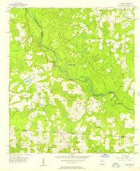
 - 1959 Map of Ellaville
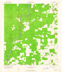
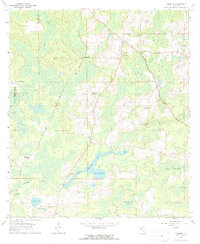
 1959 Ellaville1959 Print · USGSThe Suwannee and Withlacoochee rivers meet in this mid-century Florida landscape at the borders of Madison and Hamilton counties. Researchers can trace the grounds of the Drew Mansion, locate the Old Columbus Cemetery, and identify rural congregations like St Pauls Church.5 unique versions available
 - 1959 Map of Falmouth, 1960 Print
 1959 Falmouth1960 Print · USGSThe Suwannee River borderlands in the late fifties were a quiet stretch of pine woods and small rural outposts. Researchers can trace the path of the Southern railroad through Newburn or locate local landmarks like Falmouth Spring and the Stroud Cem.3 unique versions available
 - 1960 Map of Cherry Lake, 1961 Print
 1960 Cherry Lake1961 Print · USGSNorthern Florida's lake country is captured here in the early sixties as rural life centered around the water and the rail. Genealogists and historians can locate family-named landmarks and community hubs like Cherry Lake 4-H Camp, Jestlamb Sch, and New Hopeful Ch.3 unique versions available
 - 1960 Map of Pinetta, 1961 Print
 1960 Pinetta1961 Print · USGSMadison County, Florida, is captured at the dawn of the 1960s, showing a landscape defined by small hamlets and the Withlacoochee River. Researchers can trace old rail lines like the Valdosta Southern or locate family-named landmarks like Leland and Smiths Pond.4 unique versions available
 - 1962 Map of Ashville, 1964 Print
 1962 Ashville1964 Print · USGSJefferson and Madison counties remained a pastoral landscape of river swamps and country churches during the early sixties. Genealogists can trace family roots through the many local congregations, including Macedonia Ch, Antioch Ch, and the Old Greenville Ch Bethel Sch.2 unique versions available
 - 1962 Map of Hamburg, 1964 Print
 1962 Hamburg1964 Print · USGSMadison County's wet hammocks and river forks are detailed here in the early sixties. Researchers can trace the Southern Railroad Grade and find historic community centers like Hamburg and the Reaper Cem.3 unique versions available
 - 1979 Map of Perry, 1980 Print
 1979 Perry1980 Print · USGSThe Florida Big Bend and Suwannee River valley are captured here in the late seventies during a period of established timber and rail activity. Genealogists and historians can trace the Live Oak Perry and South Georgia line through Scanlon or locate family roots in Dowling Park and Greenville.2 unique versions available
 - 1981 Map of Valdosta
 1981 Valdosta1981 Print · USGSCrossing the Georgia and Florida border in the early eighties, this survey captures the agricultural and military landscape of the coastal plain. Genealogists and historians can trace the rail-linked growth of Valdosta and Quitman or find rural landmarks like New Hope Church and Lake Miccosukee.
Showing maps 1-25 of 128
Top cities of Madison County
Frequently asked questions
- What are the different types of historical maps available for Madison County?
- What is the oldest map of Madison County?
- Where can I purchase historical maps of Madison County for my home or office?
- Where can I download high-res historical maps of Madison County?
- Are there historical topographic maps available for Madison County?
- Is there historical aerial imagery available for Madison County?
- Where are historical maps of Madison County sourced from?