1940s Maps of Bradenton, Florida
Explore 6 historic maps of Bradenton from the 1940s. These maps offer a rare glimpse into what life looked like during the 1940s — showing old roads, neighborhoods, homes, and landmarks that have changed or disappeared over time.
Whether you're researching your family's past, planning a metal detecting trip, or studying how Bradenton's landscape evolved across the 1940s, these high-resolution maps are a powerful tool for exploring the history of this region.
- Focus on a specific era: All maps on this page are from the 1940s, giving you a focused view of this time period.
- See what’s changed: Compare century-old streets, trails, and buildings to today's modern landscape using overlays and satellite layers.
- Research with precision: Use these maps for genealogy, historical research, land use analysis, or educational projects.
- View, download, or print: Maps are fully viewable online in high resolution, and can be downloaded or printed for your own records.
Start exploring Bradenton's history through authentic maps from the 1940s. This is your window into the past.
Bradenton, FL maps
(6)- 1944 Map of Anna Maria
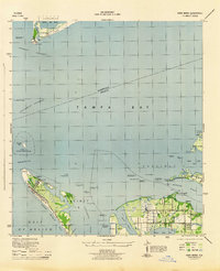 1944 Anna Maria1944 Print · USGSCoastal Manatee County is captured during the mid-forties, showing the early layout of Anna Maria and the mainland groves of Palma Sola. Trace the old shoreline landmarks from the Municipal Pier to the ancient Portavant Mound and the isolated Passage Key.2 unique versions available
 - 1944 Map of Lorraine
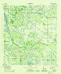 1944 Lorraine1944 Print · USGSManatee County was a patchwork of wetlands and early settlements during the mid-forties, revealing the landscape before modern suburban expansion. You can trace the historic Old RR Grade, locate the Braden River Cem, and follow the original paths of Rye Grade and Arcadia Road.2 unique versions available
 - 1944 Map of Ellenton
 1944 Ellenton1944 Print · USGSThe Manatee River coastline and Tampa Bay wetlands appear here during the mid-1940s, showing the early footprints of coastal Florida towns. Trace historical rail lines and settlements like Ellenton and Rubonia, or find the clay deposits at Fullers Earth.2 unique versions available
 - 1944 Map of Parish
 1944 Parish1944 Print · USGSManatee County was a landscape of railroads and river bends during the mid-1940s, centered on the growing community of Parish. Researchers can trace old precincts, rural churches like New Bethel Church, and historic river landmarks including Fort Hamer.2 unique versions available
 - 1944 Map of Bradenton Beach
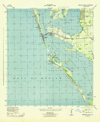 1944 Bradenton Beach1944 Print · USGSThe Florida Gulf Coast appears here during the mid-forties, showing the early settlement of the barrier islands and wartime infrastructure. Genealogists and coastal historians can trace the footprints of Bradenton Beach, Longbeach, and the Army Firing Range.2 unique versions available
 - 1947 Map of Bradenton
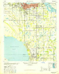 1947 Bradenton1947 Print · USGSCoastal Florida is shown in transition during the late 1940s, from the city streets of Bradenton to the large military installation at the Sarasota US Army Air Base. Researchers can trace the early layout of Whitfield Estates, locate the Manasota Cem, or find the original Prospect School site.
End of results
Showing maps 1-6 of 6
Top cities near Bradenton
- Saint Petersburg historical maps
- Sarasota historical maps
- Palmetto historical maps
- Saint Pete Beach historical maps
- Longboat Key historical maps
- Siesta Key historical maps
See more
Top neighborhoods of Bradenton
Frequently asked questions
- What are the different types of historical maps available for Bradenton?
- What is the oldest map of Bradenton?
- Where can I purchase historical maps of Bradenton for my home or office?
- Where can I download high-res historical maps of Bradenton?
- Are there historical topographic maps available for Bradenton?
- Is there historical aerial imagery available for Bradenton?
- Where are historical maps of Bradenton sourced from?