1960s Maps of Bradenton, Florida
Explore 5 historic maps of Bradenton from the 1960s. These maps offer a rare glimpse into what life looked like during the 1960s — showing old roads, neighborhoods, homes, and landmarks that have changed or disappeared over time.
Whether you're researching your family's past, planning a metal detecting trip, or studying how Bradenton's landscape evolved across the 1960s, these high-resolution maps are a powerful tool for exploring the history of this region.
- Focus on a specific era: All maps on this page are from the 1960s, giving you a focused view of this time period.
- See what’s changed: Compare century-old streets, trails, and buildings to today's modern landscape using overlays and satellite layers.
- Research with precision: Use these maps for genealogy, historical research, land use analysis, or educational projects.
- View, download, or print: Maps are fully viewable online in high resolution, and can be downloaded or printed for your own records.
Start exploring Bradenton's history through authentic maps from the 1960s. This is your window into the past.
Bradenton, FL maps
(5)- 1960 Map of Tampa
 1960 Tampa1960 Print · USGSThe Florida Gulf Coast was undergoing a major transformation at the start of the sixties, with new bridges linking burgeoning cities across the bays. Researchers can trace the mid-century footprints of St Petersburg and Tampa, or locate coastal landmarks like Mac Dill AFB and the Sunshine Skyway.2 unique versions available
 - 1964 Map of Palmetto, 1965 Print
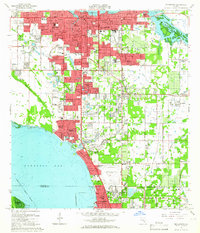
 1964 Palmetto1965 Print · USGSPalmetto and the shores of Tampa Bay are captured here in the mid-sixties as post-war growth transformed the Manatee County coast. Genealogists and researchers can trace local landmarks like Lincoln Memorial Sch, the Madira Bickel Mound, and the old Atlantic Coast Line Railroad corridors.5 unique versions available
 - 1964 Map of Bradenton Beach, 1965 Print
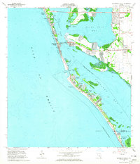 1964 Bradenton Beach1965 Print · USGSThe Florida Gulf Coast appears in the mid-sixties as a landscape of evolving barrier island communities and intricate waterways. Trace the development of Bradenton Beach and Longbeach, or locate landmarks like St Bernards Ch and the Cortez Bridge.5 unique versions available
 - 1964 Map of Anna Maria, 1965 Print
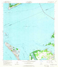 1964 Anna Maria1965 Print · USGSAnna Maria and the Manatee River shoreline are caught here in the mid-1960s, showing a mix of growing coastal settlements and preserved archaeological sites. Genealogists and historians can locate the Palma Sola Cem, Portavant Indian Mound, and the old Palma Sola Airport.3 unique versions available
 - 1964 Map of Bradenton, 1966 Print
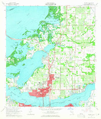
 1964 Bradenton1966 Print · USGSBradenton and the Sarasota Bay shoreline are shown here during a mid-century period of rapid coastal growth. Genealogists and local historians can locate early landmarks like Braden Castle, Manatee Jr College, and Oneco.4 unique versions available
End of results
Showing maps 1-5 of 5
Top cities near Bradenton
- Saint Petersburg historical maps
- Sarasota historical maps
- Palmetto historical maps
- Saint Pete Beach historical maps
- Longboat Key historical maps
- Siesta Key historical maps
See more
Top neighborhoods of Bradenton
Frequently asked questions
- What are the different types of historical maps available for Bradenton?
- What is the oldest map of Bradenton?
- Where can I purchase historical maps of Bradenton for my home or office?
- Where can I download high-res historical maps of Bradenton?
- Are there historical topographic maps available for Bradenton?
- Is there historical aerial imagery available for Bradenton?
- Where are historical maps of Bradenton sourced from?