1970s Maps of Bradenton, Florida
Explore 4 historic maps of Bradenton from the 1970s. These maps offer a rare glimpse into what life looked like during the 1970s — showing old roads, neighborhoods, homes, and landmarks that have changed or disappeared over time.
Whether you're researching your family's past, planning a metal detecting trip, or studying how Bradenton's landscape evolved across the 1970s, these high-resolution maps are a powerful tool for exploring the history of this region.
- Focus on a specific era: All maps on this page are from the 1970s, giving you a focused view of this time period.
- See what’s changed: Compare century-old streets, trails, and buildings to today's modern landscape using overlays and satellite layers.
- Research with precision: Use these maps for genealogy, historical research, land use analysis, or educational projects.
- View, download, or print: Maps are fully viewable online in high resolution, and can be downloaded or printed for your own records.
Start exploring Bradenton's history through authentic maps from the 1970s. This is your window into the past.
Bradenton, FL maps
(4)- 1972 Map of Tampa, 1974 Print
 1972 Tampa1974 Print · USGSThe Florida Gulf Coast appears in a period of significant growth during the early seventies, from the urban centers of the bay to the quiet southern keys. Researchers can trace the expansion of St Petersburg or locate family sites near Safety Harbor, Valrico, and Boca Ciega.
 - 1973 Map of Parrish, 1974 Print
 1973 Parrish1974 Print · USGSManatee County in the early seventies shows a landscape of riverfront camps and railroad junctions. Genealogists and local historians can trace the foundations of Parrish near St Marys Ch, the Fortner Cem, and the historic Fort Hamer Boat Ramp.3 unique versions available
 - 1973 Map of Lorraine, 1975 Print
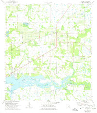
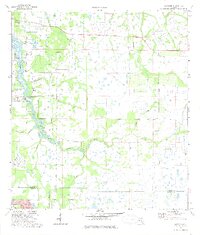 1973 Lorraine1975 Print · USGSThe Braden River watershed in the early 1970s reveals a Florida landscape of cypress strands and winding sloughs before major suburban expansion. Genealogists and local historians can locate the Braden River Cemetery, the settlement of Lorraine, and the Old Railroad Grade.3 unique versions available
 - 1979 Map of Sarasota, 1980 Print
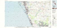 1979 Sarasota1980 Print · USGSCoastal Florida in the late seventies reveals the rapid growth of the Gulf shoreline from Bradenton down to Port Charlotte. Trace the expansion of coastal communities like Bayshore Gardens, find long-standing landmarks like Trailer Estates, or explore the vast preserve of Myakka River State Park.
End of results
Showing maps 1-4 of 4
Top cities near Bradenton
- Saint Petersburg historical maps
- Sarasota historical maps
- Palmetto historical maps
- Saint Pete Beach historical maps
- Longboat Key historical maps
- Siesta Key historical maps
See more
Top neighborhoods of Bradenton
Frequently asked questions
- What are the different types of historical maps available for Bradenton?
- What is the oldest map of Bradenton?
- Where can I purchase historical maps of Bradenton for my home or office?
- Where can I download high-res historical maps of Bradenton?
- Are there historical topographic maps available for Bradenton?
- Is there historical aerial imagery available for Bradenton?
- Where are historical maps of Bradenton sourced from?