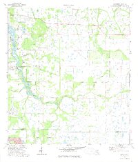
1973 Map of Lorraine
USGS Topo · Published 1975About this map
The Braden River winds through this 1970s landscape of eastern Manatee County, serving as the primary drainage for a network of wetlands and creeks including Williams Creek, Cooper Creek, and Gates Creek. The area shows a transition from the established community at Elwood Park and the settlement of Lorraine toward more rural terrain. Inland, the presence of the Old Railroad Grade and Rye Road marks the legacy of earlier transportation and logging routes that once navigated the cypress-heavy environment. Water management is evident through the development of Ward Lake and features like the Pumping Station and Sewage Disposal. For those interested in local history, the map preserves the location of Jiggs Landing and the Braden River Cemetery, while the northern boundary reaches toward the small community of Foxleigh.
Find a feature on this map
25 named features on this map. Tap any name to fly to it.
Don’t see what you’re looking for? This feature index may not catch every label — zoom into the map to look around manually.
Map Details
Editions of this 1973 Lorraine Map
3 editions found
Other maps of this area

1921 · Fort De Soto
USGS Topo · 1:62,500

1944 · Sarasota
USGS Topo · 1:31,680

1944 · Rye
USGS Topo · 1:31,680

1944 · Verna
USGS Topo · 1:31,680

1944 · Lorraine
USGS Topo · 1:31,680

1944 · Ellenton
USGS Topo · 1:31,680

1944 · Parish
USGS Topo · 1:31,680

1944 · Miakka
USGS Topo · 1:31,680

1947 · Bradenton
USGS Topo · 1:24,000

1947 · Bee Ridge
USGS Topo · 1:24,000