
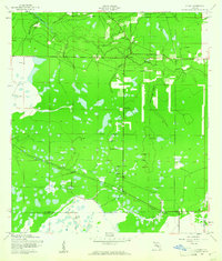
1944 Map of Verna
USGS Topo · Published 1944About this map
The Manatee River snakes through the northern reaches of this Florida interior landscape, its banks fed by numerous tributaries such as Gilley Cr. and Fisher Branch. This mid-century survey illustrates the rural infrastructure of the region during the war years, highlighting the small settlements of Waterbury and Verna. Transportation patterns are clearly defined by the Waterbury Road and the prominent Old RR Grade, which cuts diagonally across the southern half of the quadrangle, indicating a landscape in transition from its earlier rail-dependent industrial era.
Find a feature on this map
36 named features on this map. Tap any name to fly to it.
Don’t see what you’re looking for? This feature index may not catch every label — zoom into the map to look around manually.
Map Details
Editions of this 1944 Verna Map
2 editions found
Other maps of this area

1944 · Rye
USGS Topo · 1:31,680

1944 · Lorraine
USGS Topo · 1:31,680

1944 · Parish
USGS Topo · 1:31,680

1944 · Miakka
USGS Topo · 1:31,680

1947 · Bee Ridge
USGS Topo · 1:24,000

1956 · Myakka City
USGS Topo · 1:24,000

1956 · Myakka City NW
USGS Topo · 1:24,000

1956 · Keentown
USGS Topo · 1:24,000

1956 · Tampa
USGS Topo · 1:250,000

1959 · Tampa
USGS Topo · 1:250,000