
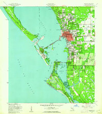
1944 Map of Sarasota
USGS Topo · Published 1944About this map
Sarasota Bay and its intricate network of barrier islands define this coastal landscape at the height of World War II. The map highlights a burgeoning downtown waterfront connected by the Ringling Causeway to St Armand Key and The Lido. Further north, Beverly Terrace and the Booker Schools anchor the residential core, while the rail infrastructure of the Seaboard Air Line and Atlantic Coast Line indicates the city's role as a regional transport hub. To the south, inland developments like Sarasota Heights and Hayden show the early expansion of the city away from the shoreline. The inclusion of the Sarasota Airport and Payne Terminal reflects the mid-century integration of air and maritime commerce, providing a detailed view of the infrastructure that supported the Florida Gulf Coast during this pivotal decade.
Find a feature on this map
48 named features on this map. Tap any name to fly to it.
Don’t see what you’re looking for? This feature index may not catch every label — zoom into the map to look around manually.
Map Details
Editions of this 1944 Sarasota Map
2 editions found
Other maps of this area

1943 · Laurel
USGS Topo · 1:24,000

1944 · Bird Keys
USGS Topo · 1:31,680

1944 · Laurel
USGS Topo · 1:31,680

1944 · Lorraine
USGS Topo · 1:31,680

1944 · Bradenton Beach
USGS Topo · 1:31,680

1947 · Bradenton
USGS Topo · 1:24,000

1947 · Bee Ridge
USGS Topo · 1:24,000

1956 · Tampa
USGS Topo · 1:250,000

1959 · Tampa
USGS Topo · 1:250,000

1960 · Tampa
USGS Topo · 1:250,000