1990s Maps of Marion County, Florida
Explore 20 historic maps of Marion County from the 1990s. These maps offer a rare glimpse into what life looked like during the 1990s — showing old roads, neighborhoods, homes, and landmarks that have changed or disappeared over time.
Whether you're researching your family's past, planning a metal detecting trip, or studying how Marion County's landscape evolved across the 1990s, these high-resolution maps are a powerful tool for exploring the history of this region.
- Focus on a specific era: All maps on this page are from the 1990s, giving you a focused view of this time period.
- See what’s changed: Compare century-old streets, trails, and buildings to today's modern landscape using overlays and satellite layers.
- Research with precision: Use these maps for genealogy, historical research, land use analysis, or educational projects.
- View, download, or print: Maps are fully viewable online in high resolution, and can be downloaded or printed for your own records.
Start exploring Marion County's history through authentic maps from the 1990s. This is your window into the past.
Marion County, FL maps
(20)- 1991 Map of Ocala West
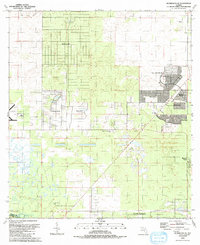
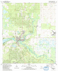
 1991 Ocala West1991 Print · USGSOcala's western corridor was rapidly evolving into a regional hub of education and aviation during the early nineties. Researchers can trace the development of Central Florida Jr College and local landmarks like Vanguard High Sch and the Old Railroad Grade.
 - 1991 Map of Cotton Plant
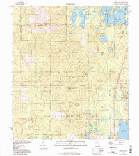
 1991 Cotton Plant1991 Print · USGSMarion County in the early nineties reveals a transition from traditional rural life to a noted equestrian and residential landscape. Researchers can trace historic church sites and cemeteries like Wesley Chapel Cem and Siloam Ch Cem alongside the Classic Mile Racetrack.
 - 1991 Map of Dunnellon SE
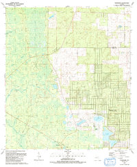
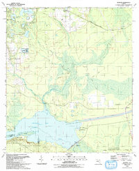
 1991 Dunnellon SE1991 Print · USGSMarion County enters a decade of rapid transformation in the early nineties as residential communities expand across the landscape. Genealogists and historians can trace the growth of Oak Run and Marion Oaks alongside rural landmarks like Cedar Grove Ch.
 - 1991 Map of Tidewater
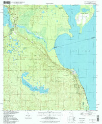
 1991 Tidewater1991 Print · USGSLevy and Marion County's borderlands appear here in the early nineties, showing a mix of established wetlands and new residential planning. Genealogists and hikers can trace the Old Railroad Grade past Tidewater or locate the Sand Pond Cem near Sand Slough.
 - 1991 Map of Belleview
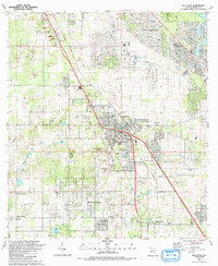 1991 Belleview1991 Print · USGSMarion County is seen during a period of steady residential expansion in the early nineties, centered on the historic crossroads at Belleview. Family researchers and local historians can trace legacy sites like Burrell Cem, Mt Pisgah Ch, and the Monroe Landing Strip.
 - 1991 Map of Romeo
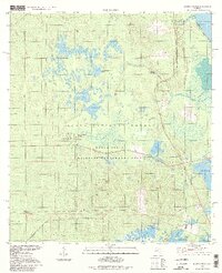
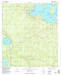
 1991 Romeo1991 Print · USGSMarion and Levy counties are captured here in the early nineties, showing a landscape of traditional Florida prairies and modern residential growth. Researchers can locate community anchors like Zion Hill Cem and trace the early layouts of Rainbow Lakes and Rainbow Park.
 - 1991 Map of Dunnellon
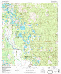
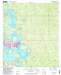
 1991 Dunnellon1991 Print · USGSDunnellon and the surrounding river country are captured here in the early nineties as suburban expansion began to meet the Florida wilderness. Genealogists can trace family names at Rockwell Cem or locate historic congregations like Beulah Ch and New Second Bethel Ch.
 - 1991 Map of Ocala East
 1991 Ocala East1991 Print · USGSThe eastern edges of Ocala and the headwaters of the Silver River are captured here during the rapid development of the early nineties. Genealogists and researchers can trace local landmarks like Highland Memorial Park (Cem), the Fort King Burial Grounds, and the rail lines of the Seaboard System.
 - 1991 Map of Shady
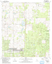
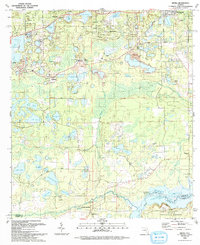
 1991 Shady1991 Print · USGSMarion County experiences significant residential expansion during the early nineties, with emerging suburban tracts appearing alongside rural homesteads. Genealogists and researchers can trace local roots through landmarks like Barnes Cem, Shady Grove Ch, and the settlements of Shady and Martel.
 - 1991 Map of Yankeetown SE
 1991 Yankeetown SE1991 Print · USGSIn the early 1990s, this area of Levy and Citrus counties showed a landscape shaped by water management and emerging residential tracts. Trace the engineering of the Barge Canal and Inglis Lock, or locate rural burial sites like Robinson Cem and Dog Ear Cem.
 - 1993 Map of Rodman
 1993 Rodman1993 Print · USGSThis part of Putnam County in the early 1990s shows a landscape shaped by the Cross Florida Barge Canal project and the Ocala National Forest. Researchers can trace the Old Railroad Grade or locate family sites like the King-Strickland-Walker Cem and Cedar Landing.
 - 1993 Map of Keuka
 1993 Keuka1993 Print · USGSPutnam County's lake-strewn landscape is captured here in the early nineties, showing the intersection of small-town life and the edge of the Ocala National Forest. You can trace historical rural landmarks from Fort Brook Landing on the river to old spiritual centers like Mt Bethel Ch and Magnolia Church.
 - 1994 Map of Juniper Springs, 1998 Print
 1994 Juniper Springs1998 Print · USGSThe Ocala National Forest in the mid-nineties remains a vast network of springs and prairies before further regional development. Researchers can trace the complex hydrography of Juniper Creek and find specific landmarks like the Juniper Springs Recreation Area and Fern Hammock Springs.
 - 1994 Map of Lake Kerr, 1998 Print
 1994 Lake Kerr1998 Print · USGSMarion County's lake-strewn forest interior is captured here in the 1990s, during a period of sustained conservation within the Ocala National Forest. Researchers can trace the Old Railroad Grade and locate historic points like Kerr City and the Eureka Lookout Tower.
 - 1994 Map of Farles Lake, 1998 Print
 1994 Farles Lake1998 Print · USGSThe Ocala National Forest interior comes alive in the mid-1990s, showing a landscape defined by wetlands and federal management. Trace the local geography of Pittman, the northern reaches of Lake Dorr, and the remote outposts at Camp Ocala or the Lookout Tower.
 - 1994 Map of Lake Mary, 1998 Print
 1994 Lake Mary1998 Print · USGSMarion County's deep woods and prairie wetlands are preserved here in the late twentieth century. Researchers can locate the Moss Bluff Ch and trace the shores of Lake Mary, Doe Lake, and Lake Catherine within the sprawling Ocala National Forest.
 - 1994 Map of Welaka, 1998 Print
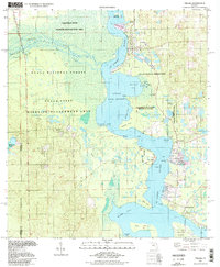 1994 Welaka1998 Print · USGSThe St. Johns riverfront and the northern reaches of Lake George come into focus in this late-twentieth-century study of Putnam County. Genealogists and local researchers can trace old river landings and settlements like Welaka, Norwalk, and the expansive Drayton Island.
 - 1994 Map of Salt Springs, 1998 Print
 1994 Salt Springs1998 Print · USGSFlorida's riverine borderlands are detailed here in the 1990s, where the St Johns River meets the vast freshwater expanse of Lake George. Trace the waterways from Salt Springs to the marshy reaches of Hopkins Prairie or the shores of Drayton Island.
 - 1999 Map of Halfmoon Lake, 2001 Print
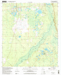
 1999 Halfmoon Lake2001 Print · USGSMarion County's lake-strewn forest interior comes into focus during the late twentieth century, showing a landscape shaped by water and woods. Genealogists and local historians can trace family locations near Lynn, Woods and Lakes, or the Lookout Tower within the Ocala National Forest.
 - 1999 Map of Fort Mc Coy, 2001 Print
 1999 Fort Mc Coy2001 Print · USGSMarion County at the end of the twentieth century remains a landscape of river landings and dense forest. Genealogists and researchers can trace local family ties and land use through Fort McCoy, the Cem sites, and landings like Osceola Landing or Gores Landing.
End of results
Showing maps 1-20 of 20
Top cities of Marion County
- Ocala historical maps
- Citra historical maps
- Rainbow Springs historical maps
- Belleview historical maps
- Dunnellon historical maps
- Reddick historical maps
See more
Frequently asked questions
- What are the different types of historical maps available for Marion County?
- What is the oldest map of Marion County?
- Where can I purchase historical maps of Marion County for my home or office?
- Where can I download high-res historical maps of Marion County?
- Are there historical topographic maps available for Marion County?
- Is there historical aerial imagery available for Marion County?
- Where are historical maps of Marion County sourced from?