1960s Maps of Ocala, Florida
Explore 3 historic maps of Ocala from the 1960s. These maps offer a rare glimpse into what life looked like during the 1960s — showing old roads, neighborhoods, homes, and landmarks that have changed or disappeared over time.
Whether you're researching your family's past, planning a metal detecting trip, or studying how Ocala's landscape evolved across the 1960s, these high-resolution maps are a powerful tool for exploring the history of this region.
- Focus on a specific era: All maps on this page are from the 1960s, giving you a focused view of this time period.
- See what’s changed: Compare century-old streets, trails, and buildings to today's modern landscape using overlays and satellite layers.
- Research with precision: Use these maps for genealogy, historical research, land use analysis, or educational projects.
- View, download, or print: Maps are fully viewable online in high resolution, and can be downloaded or printed for your own records.
Start exploring Ocala's history through authentic maps from the 1960s. This is your window into the past.
Ocala, FL maps
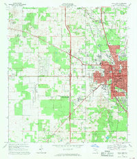
(3)- 1967 Map of Ocala East, 1969 Print
 1967 Ocala East1969 Print · USGSThe eastern edges of Ocala and the famous waters of Silver Springs are captured here during a pivotal era of infrastructure planning. Trace the route of the Proposed Cross Florida Barge Canal and locate historic sites like the Fort King Burial Grounds and Camp Roosevelt.
 - 1968 Map of Ocala West, 1969 Print
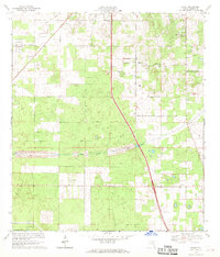
 1968 Ocala West1969 Print · USGSOcala entered a period of rapid westward expansion in the late sixties, as new residential developments began to crest the local limestone ridges. Researchers can trace the footprint of community institutions like Central Florida Jr College and Howard High Sch or locate family plots at Kendrick Cem and Lincoln Mem Cem.2 unique versions available
 - 1968 Map of Shady, 1970 Print
 1968 Shady1970 Print · USGSMarion County in the late sixties shows a landscape on the verge of massive change as the Proposed Cross Florida Barge Canal was being surveyed. Researchers can trace rural community roots at Shady Grove Ch, locate the old RR Grade, or find the former Claypit and Lookout Tower.
End of results
Showing maps 1-3 of 3
Top cities near Ocala
Top neighborhoods of Ocala
- Maricamp historical maps
- Cimarron historical maps
- Fore Ranch historical maps
- Carlton Arms historical maps
- Canterbury Circle Apartments historical maps
- Parkside Garden Apartments historical maps
See more
Frequently asked questions
- What are the different types of historical maps available for Ocala?
- What is the oldest map of Ocala?
- Where can I purchase historical maps of Ocala for my home or office?
- Where can I download high-res historical maps of Ocala?
- Are there historical topographic maps available for Ocala?
- Is there historical aerial imagery available for Ocala?
- Where are historical maps of Ocala sourced from?