1900s (20th Century) Maps of Kendall, Florida
Explore 12 historic maps of Kendall from the 1900s (20th Century). These maps offer a rare glimpse into what life looked like during the 1900s — showing old roads, neighborhoods, homes, and landmarks that have changed or disappeared over time.
Whether you're researching your family's past, planning a metal detecting trip, or studying how Kendall's landscape evolved across the 1900s, these high-resolution maps are a powerful tool for exploring the history of this region.
- Focus on a specific era: All maps on this page are from the 1900s, giving you a focused view of this time period.
- See what’s changed: Compare century-old streets, trails, and buildings to today's modern landscape using overlays and satellite layers.
- Research with precision: Use these maps for genealogy, historical research, land use analysis, or educational projects.
- View, download, or print: Maps are fully viewable online in high resolution, and can be downloaded or printed for your own records.
Start exploring Kendall's history through authentic maps from the 1900s. This is your window into the past.
Kendall, FL maps
(12)- 1949 Map of South Miami NW
 1949 South Miami NW1949 Print · USGSIn the late 1940s, the western edge of Miami-Dade County was a landscape of emerging infrastructure and military footprints. Genealogists and local historians can trace the early development of Richmond, the Tamiami Airport, and the Seaboard Air Line corridor.2 unique versions available
 - 1950 Map of South Miami
 1950 South Miami1950 Print · USGSCoastal Miami-Dade County was undergoing a massive post-war transformation at mid-century as suburbs pushed west from the bay. Researchers can find early layouts for CORAL GABLES, the fledgling campus of the University of Miami, and the site of Browns Airport.2 unique versions available
 - 1955 Map of South Miami NW, 1957 Print
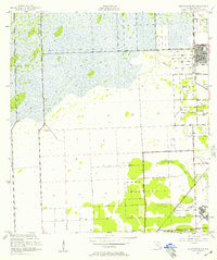 1955 South Miami NW1957 Print · USGSSuburban development begins to push into the Everglades in the mid-1950s, showing the early layouts of Westwood Lake and Richmond Heights. Genealogists and historians can trace the foundations of the University of Miami and the US Naval Air Station.4 unique versions available
 - 1956 Map of South Miami, 1957 Print
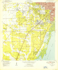
 1956 South Miami1957 Print · USGSGreater Miami and Coral Gables underwent a period of significant post-war expansion during the mid-fifties. Genealogists and local historians can trace the development of suburban enclaves like West Miami and Kendall or locate landmarks such as the Venetian Pool and Tropical Park.2 unique versions available
 - 1956 Map of Miami, 1963 Print
 1956 Miami1963 Print · USGSSouthern Florida experiences post-war expansion in the 1950s, even as the wilderness remains dominant across the southern peninsula. Genealogists and historians can trace suburban growth in Opa-locka and Perrine or locate remote sites like the Tamiami Ranger Station.5 unique versions available
 - 1958 Map of Miami
 1958 Miami1958 Print · USGSSoutheast Florida in the late fifties reveals a coastal boom held in balance with the wild sawgrass and mangroves of Everglades National Park. Trace the paths of the Florida East Coast RR through Homestead or locate the U S Marine Corps Air Station during the height of the Cold War.
 - 1981 Map of Miami, 1982 Print
 1981 Miami1982 Print · USGSThe Miami metropolitan corridor and the vast marshlands of the interior are seen here in the early 1980s. Trace the reach of Florida's Turnpike and the Florida East Coast Railway past Opa-locka, Coral Gables, and the Miami International Airport.
 - 1988 Map of Miami
 1988 Miami1988 Print · USGSSouth Florida in the late eighties shows the sharp edge between the growing urban Atlantic coast and the vast wetlands of Everglades National Park. Researchers can trace the path of the Tamiami Trail and locate coastal settlements like Ochopee or Chokoloskee.
 - 1988 Map of South Miami
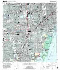
 1988 South Miami1988 Print · USGSCoastal Miami-Dade County comes alive in the late eighties as suburban growth transforms former agricultural lands into bustling neighborhoods. Trace family roots and local development through landmarks like Dadeland Mall, The Falls Mall, and the historic Venetian Pool.
 - 1988 Map of South Miami NW
 1988 South Miami NW1988 Print · USGSSuburban Miami-Dade expands rapidly during the late eighties, showing a landscape defined by residential growth and major infrastructure. Researchers can trace development around The Hammocks, Tamiami Airport, and Richmond Heights.
 - 1994 Map of South Miami, 2000 Print
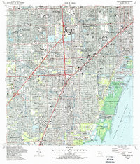
 1994 South Miami2000 Print · USGSCoastal Miami-Dade County in the mid-1990s shows a mature landscape of suburban expansion and significant institutional footprints. Researchers can trace the development of Coral Gables, the University of Miami campus, and local landmarks like the Venetian Pool and Dadeland Mall.
 - 1994 Map of South Miami NW, 2000 Print
 1994 South Miami NW2000 Print · USGSSuburban Miami-Dade County expanded westward toward the Everglades in the 1990s, creating a grid of residential lakes and canals. Researchers can trace local development through the layout of The Hammocks, the Tamiami Airport, and Richmond Heights.
End of results
Showing maps 1-12 of 12
Top cities near Kendall
- Miami historical maps
- Hialeah historical maps
- Miami Beach historical maps
- Homestead historical maps
- North Miami historical maps
- Coral Gables historical maps
See more
Top neighborhoods of Kendall
- Green-Mar Acres historical maps
- Howard historical maps
- Hawley Heights historical maps
- Spanish Trace condominiums historical maps
- Centris historical maps
Frequently asked questions
- What are the different types of historical maps available for Kendall?
- What is the oldest map of Kendall?
- Where can I purchase historical maps of Kendall for my home or office?
- Where can I download high-res historical maps of Kendall?
- Are there historical topographic maps available for Kendall?
- Is there historical aerial imagery available for Kendall?
- Where are historical maps of Kendall sourced from?