1990s Maps of Kendall, Florida
Explore 2 historic maps of Kendall from the 1990s. These maps offer a rare glimpse into what life looked like during the 1990s — showing old roads, neighborhoods, homes, and landmarks that have changed or disappeared over time.
Whether you're researching your family's past, planning a metal detecting trip, or studying how Kendall's landscape evolved across the 1990s, these high-resolution maps are a powerful tool for exploring the history of this region.
- Focus on a specific era: All maps on this page are from the 1990s, giving you a focused view of this time period.
- See what’s changed: Compare century-old streets, trails, and buildings to today's modern landscape using overlays and satellite layers.
- Research with precision: Use these maps for genealogy, historical research, land use analysis, or educational projects.
- View, download, or print: Maps are fully viewable online in high resolution, and can be downloaded or printed for your own records.
Start exploring Kendall's history through authentic maps from the 1990s. This is your window into the past.
Kendall, FL maps
(2)- 1994 Map of South Miami, 2000 Print
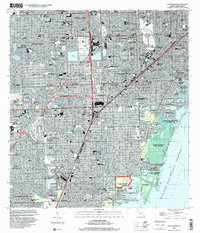 1994 South Miami2000 Print · USGSCoastal Miami-Dade County in the mid-1990s shows a mature landscape of suburban expansion and significant institutional footprints. Researchers can trace the development of Coral Gables, the University of Miami campus, and local landmarks like the Venetian Pool and Dadeland Mall.
 - 1994 Map of South Miami NW, 2000 Print
 1994 South Miami NW2000 Print · USGSSuburban Miami-Dade County expanded westward toward the Everglades in the 1990s, creating a grid of residential lakes and canals. Researchers can trace local development through the layout of The Hammocks, the Tamiami Airport, and Richmond Heights.
End of results
Showing maps 1-2 of 2
Top cities near Kendall
- Miami historical maps
- Hialeah historical maps
- Miami Beach historical maps
- Homestead historical maps
- North Miami historical maps
- Coral Gables historical maps
See more
Top neighborhoods of Kendall
- Green-Mar Acres historical maps
- Howard historical maps
- Hawley Heights historical maps
- Spanish Trace condominiums historical maps
- Centris historical maps
Frequently asked questions
- What are the different types of historical maps available for Kendall?
- What is the oldest map of Kendall?
- Where can I purchase historical maps of Kendall for my home or office?
- Where can I download high-res historical maps of Kendall?
- Are there historical topographic maps available for Kendall?
- Is there historical aerial imagery available for Kendall?
- Where are historical maps of Kendall sourced from?