1980s Maps of Miami, Florida
Explore 6 historic maps of Miami from the 1980s. These maps offer a rare glimpse into what life looked like during the 1980s — showing old roads, neighborhoods, homes, and landmarks that have changed or disappeared over time.
Whether you're researching your family's past, planning a metal detecting trip, or studying how Miami's landscape evolved across the 1980s, these high-resolution maps are a powerful tool for exploring the history of this region.
- Focus on a specific era: All maps on this page are from the 1980s, giving you a focused view of this time period.
- See what’s changed: Compare century-old streets, trails, and buildings to today's modern landscape using overlays and satellite layers.
- Research with precision: Use these maps for genealogy, historical research, land use analysis, or educational projects.
- View, download, or print: Maps are fully viewable online in high resolution, and can be downloaded or printed for your own records.
Start exploring Miami's history through authentic maps from the 1980s. This is your window into the past.
Miami, FL maps
(6)- 1981 Map of Miami, 1982 Print
 1981 Miami1982 Print · USGSThe Miami metropolitan corridor and the vast marshlands of the interior are seen here in the early 1980s. Trace the reach of Florida's Turnpike and the Florida East Coast Railway past Opa-locka, Coral Gables, and the Miami International Airport.
 - 1988 Map of Miami
 1988 Miami1988 Print · USGSSouth Florida in the late eighties shows the sharp edge between the growing urban Atlantic coast and the vast wetlands of Everglades National Park. Researchers can trace the path of the Tamiami Trail and locate coastal settlements like Ochopee or Chokoloskee.
 - 1988 Map of Key Biscayne
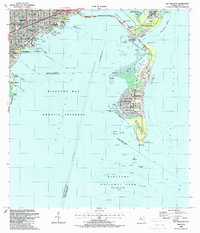 1988 Key Biscayne1988 Print · USGSMiami and the northern Keys are captured in the late eighties as urban growth met protected coastal waters. Researchers can trace the layout of Coconut Grove or find local landmarks like St Agnes Sch and the Old Lighthouse Tower.
 - 1988 Map of South Miami
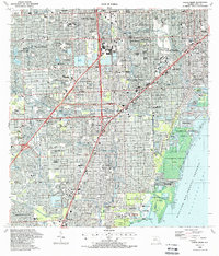 1988 South Miami1988 Print · USGSCoastal Miami-Dade County comes alive in the late eighties as suburban growth transforms former agricultural lands into bustling neighborhoods. Trace family roots and local development through landmarks like Dadeland Mall, The Falls Mall, and the historic Venetian Pool.
 - 1988 Map of Miami
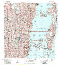 1988 Miami1988 Print · USGSGreater Miami flourished as a global gateway by the late eighties, spanning from the mainland neighborhoods to the artificial islands of the bay. You can trace urban expansion and maritime infrastructure through landmarks like the Orange Bowl Stadium, Lincoln Mem Park (Cem), and the Seaboard System rail lines.2 unique versions available
 - 1988 Map of Hialeah
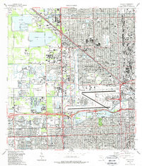 1988 Hialeah1988 Print · USGSMiami-Dade County in the late eighties shows a landscape shaped by rapid suburban expansion and massive infrastructure. Genealogists and local historians can trace the development of Hialeah and Sweetwater, locating sites like Flagler Mem Park Cem and the Hialeah Speedway.
End of results
Showing maps 1-6 of 6
Top cities near Miami
- Hialeah historical maps
- Pembroke Pines historical maps
- Kendall historical maps
- Miramar historical maps
- Miami Gardens historical maps
- Miami Beach historical maps
See more
Top neighborhoods of Miami
- Fronton Trailer Park historical maps
- Alameda historical maps
- HMS Bounty historical maps
- Liberty Square historical maps
- Bayshore historical maps
- South Bay Estates historical maps
See more
Frequently asked questions
- What are the different types of historical maps available for Miami?
- What is the oldest map of Miami?
- Where can I purchase historical maps of Miami for my home or office?
- Where can I download high-res historical maps of Miami?
- Are there historical topographic maps available for Miami?
- Is there historical aerial imagery available for Miami?
- Where are historical maps of Miami sourced from?