1990s Maps of Miami, Florida
Explore 4 historic maps of Miami from the 1990s. These maps offer a rare glimpse into what life looked like during the 1990s — showing old roads, neighborhoods, homes, and landmarks that have changed or disappeared over time.
Whether you're researching your family's past, planning a metal detecting trip, or studying how Miami's landscape evolved across the 1990s, these high-resolution maps are a powerful tool for exploring the history of this region.
- Focus on a specific era: All maps on this page are from the 1990s, giving you a focused view of this time period.
- See what’s changed: Compare century-old streets, trails, and buildings to today's modern landscape using overlays and satellite layers.
- Research with precision: Use these maps for genealogy, historical research, land use analysis, or educational projects.
- View, download, or print: Maps are fully viewable online in high resolution, and can be downloaded or printed for your own records.
Start exploring Miami's history through authentic maps from the 1990s. This is your window into the past.
Miami, FL maps
(4)- 1994 Map of Miami, 1999 Print
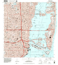 1994 Miami1999 Print · USGSGreater Miami in the mid-nineties shows a metropolis deeply integrated with the surrounding waters of the Biscayne Bay Aquatic Preserve. Researchers can locate historic landmarks like the Orange Bowl Stadium or trace the development of neighborhoods from Edison Center to Shenandoah.
 - 1994 Map of Key Biscayne, 1999 Print
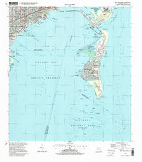 1994 Key Biscayne1999 Print · USGSBiscayne Bay and the Miami coastline are seen here in the mid-nineties, showing a landscape shaped by coastal preservation and urban expansion. Researchers can trace the development of Virginia Key and Key Biscayne through landmarks like the Seaquarium, St Agnes Sch, and the Old Lighthouse Tower.
 - 1994 Map of Hialeah, 1999 Print
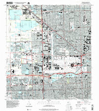 1994 Hialeah1999 Print · USGSGreater Hialeah in the 1990s is captured here as a bustling intersection of aviation, industry, and suburbia. Researchers can trace the development of Hialeah Race Track, the massive Hialeah Yards, and local schools like Hialeah High Sch.
 - 1994 Map of South Miami, 2000 Print
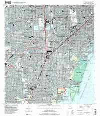 1994 South Miami2000 Print · USGSCoastal Miami-Dade County in the mid-1990s shows a mature landscape of suburban expansion and significant institutional footprints. Researchers can trace the development of Coral Gables, the University of Miami campus, and local landmarks like the Venetian Pool and Dadeland Mall.
End of results
Showing maps 1-4 of 4
Top cities near Miami
- Hialeah historical maps
- Pembroke Pines historical maps
- Kendall historical maps
- Miramar historical maps
- Miami Gardens historical maps
- Miami Beach historical maps
See more
Top neighborhoods of Miami
- Fronton Trailer Park historical maps
- Alameda historical maps
- HMS Bounty historical maps
- Liberty Square historical maps
- Bayshore historical maps
- South Bay Estates historical maps
See more
Frequently asked questions
- What are the different types of historical maps available for Miami?
- What is the oldest map of Miami?
- Where can I purchase historical maps of Miami for my home or office?
- Where can I download high-res historical maps of Miami?
- Are there historical topographic maps available for Miami?
- Is there historical aerial imagery available for Miami?
- Where are historical maps of Miami sourced from?