Old Maps of Miccosukee Indian Village, Florida for Academic Research
Study the evolution of Miccosukee Indian Village with 11 high-resolution historic maps. Whether you're teaching, researching, or modeling changes in land use, these maps provide essential visual documentation of urban, environmental, and geographic change.
- Analyze long-term change: Track patterns in development, transportation, and natural features.
- Ideal for environmental or urban studies: Support academic projects with primary historical map data.
- Use in the classroom or lab: Educators and researchers rely on these maps to bring historical context to life.
These maps are a powerful tool for teaching, research, and visualizing how Miccosukee Indian Village has changed over the decades.
Miccosukee Indian Village, FL maps
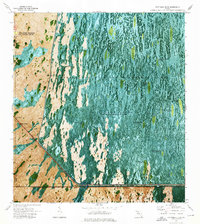
(11)- 1956 Map of Miami, 1963 Print
 1956 Miami1963 Print · USGSSouthern Florida experiences post-war expansion in the 1950s, even as the wilderness remains dominant across the southern peninsula. Genealogists and historians can trace suburban growth in Opa-locka and Perrine or locate remote sites like the Tamiami Ranger Station.5 unique versions available
 - 1958 Map of Miami
 1958 Miami1958 Print · USGSSoutheast Florida in the late fifties reveals a coastal boom held in balance with the wild sawgrass and mangroves of Everglades National Park. Trace the paths of the Florida East Coast RR through Homestead or locate the U S Marine Corps Air Station during the height of the Cold War.
 - 1973 Map of Fortymile Bend, 1975 Print
 1973 Fortymile Bend1975 Print · USGSThe Florida Everglades in the early 1970s reveal a landscape of ancestral hammocks and modern infrastructure. Genealogists and historians can trace specific family locations such as Pete Osceolas Farm, Jessie Willies Camp, and Smallpox Tommies Camp.3 unique versions available
 - 1981 Map of Miami, 1982 Print
 1981 Miami1982 Print · USGSThe Miami metropolitan corridor and the vast marshlands of the interior are seen here in the early 1980s. Trace the reach of Florida's Turnpike and the Florida East Coast Railway past Opa-locka, Coral Gables, and the Miami International Airport.
 - 1988 Map of Miami
 1988 Miami1988 Print · USGSSouth Florida in the late eighties shows the sharp edge between the growing urban Atlantic coast and the vast wetlands of Everglades National Park. Researchers can trace the path of the Tamiami Trail and locate coastal settlements like Ochopee or Chokoloskee.
 - 1995 Map of Fortymile Bend, 1999 Print
 1995 Fortymile Bend1999 Print · USGSThe Miccosukee heartland and the eastern Everglades are documented here in the mid-1990s. Researchers can trace family-named sites like Tommy Tigers Camp and Pete Oseolas Farm alongside the historic Old Burying Ground.
 - 2012 Map of Fortymile Bend, 2012 Print
 2012 Fortymile Bend2012 Print · USGSCovers Miccosukee Indian Village, including Smallpox Tommies Old Place, Fortymile Bend, and other nearby areas
 - 2015 Map of Fortymile Bend, 2015 Print
 2015 Fortymile Bend2015 Print · USGSCovers Miccosukee Indian Village, including Smallpox Tommies Old Place, Fortymile Bend, and other nearby areas
 - 2018 Map of Fortymile Bend, 2018 Print
 2018 Fortymile Bend2018 Print · USGSCovers Miccosukee Indian Village, including Smallpox Tommies Old Place, Fortymile Bend, and other nearby areas
 - 2021 Map of Fortymile Bend, 2021 Print
 2021 Fortymile Bend2021 Print · USGSCovers Miccosukee Indian Village, including Smallpox Tommies Old Place, Fortymile Bend, and other nearby areas
 - 2024 Map of Fortymile Bend, 2024 Print
 2024 Fortymile Bend2024 Print · USGSThe Florida Everglades and Big Cypress swamp converge at this critical highway junction during the 2020s. Researchers can trace the path of the Old Tamiami Trl and Loop Road Rte - 102 past landmarks like Fortymile Bend and Trail Center.
End of results
Showing maps 1-11 of 11
Top cities near Miccosukee Indian Village
Frequently asked questions
- What are the different types of historical maps available for Miccosukee Indian Village?
- What is the oldest map of Miccosukee Indian Village?
- Where can I purchase historical maps of Miccosukee Indian Village for my home or office?
- Where can I download high-res historical maps of Miccosukee Indian Village?
- Are there historical topographic maps available for Miccosukee Indian Village?
- Is there historical aerial imagery available for Miccosukee Indian Village?
- Where are historical maps of Miccosukee Indian Village sourced from?