1970s Maps of Trinity, Florida
Explore 3 historic maps of Trinity from the 1970s. These maps offer a rare glimpse into what life looked like during the 1970s — showing old roads, neighborhoods, homes, and landmarks that have changed or disappeared over time.
Whether you're researching your family's past, planning a metal detecting trip, or studying how Trinity's landscape evolved across the 1970s, these high-resolution maps are a powerful tool for exploring the history of this region.
- Focus on a specific era: All maps on this page are from the 1970s, giving you a focused view of this time period.
- See what’s changed: Compare century-old streets, trails, and buildings to today's modern landscape using overlays and satellite layers.
- Research with precision: Use these maps for genealogy, historical research, land use analysis, or educational projects.
- View, download, or print: Maps are fully viewable online in high resolution, and can be downloaded or printed for your own records.
Start exploring Trinity's history through authentic maps from the 1970s. This is your window into the past.
Trinity, FL maps
(3)- 1974 Map of Odessa, 1975 Print
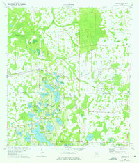 1974 Odessa1975 Print · USGSThe lake-dotted borderlands of Pasco and Hillsborough counties come into focus in the mid-1970s. Trace the rural development of Odessa and its surrounding waters, from Indian Mounds near Mound Lake to the grounds of Camp Keystone and the Odessa Ch.4 unique versions available
 - 1974 Map of Elfers, 1975 Print
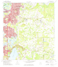 1974 Elfers1975 Print · USGSThe West Florida coast in the mid-seventies shows a landscape in transition as suburbs replaced rural sloughs and bayous. Genealogists and historians can trace the growth of New Port Richey, locate several burial grounds like East Elfers Cem, and follow the Seaboard Coast Line through Seven Springs.2 unique versions available
 - 1978 Map of Tarpon Springs, 1982 Print
 1978 Tarpon Springs1982 Print · USGSCoastal Florida is shown during its late-century period of rapid growth, from the Gulf shores to the deep inland swamps. Researchers can trace the development of the Intracoastal Waterway and locate regional landmarks like the Anclote Missile Tracking Annex and Lake Tarpon.
End of results
Showing maps 1-3 of 3
Top cities near Trinity
- Tampa historical maps
- Clearwater historical maps
- Palm Harbor historical maps
- Dunedin historical maps
- East Lake historical maps
- Bayonet Point historical maps
See more
Top neighborhoods of Trinity
- Fox Hollow historical maps
- Spyglass historical maps
- Hampton Cove historical maps
- Bellerive historical maps
- Foxwood historical maps
Frequently asked questions
- What are the different types of historical maps available for Trinity?
- What is the oldest map of Trinity?
- Where can I purchase historical maps of Trinity for my home or office?
- Where can I download high-res historical maps of Trinity?
- Are there historical topographic maps available for Trinity?
- Is there historical aerial imagery available for Trinity?
- Where are historical maps of Trinity sourced from?