1940s Maps of Trinity, Florida
Explore 6 historic maps of Trinity from the 1940s. These maps offer a rare glimpse into what life looked like during the 1940s — showing old roads, neighborhoods, homes, and landmarks that have changed or disappeared over time.
Whether you're researching your family's past, planning a metal detecting trip, or studying how Trinity's landscape evolved across the 1940s, these high-resolution maps are a powerful tool for exploring the history of this region.
- Focus on a specific era: All maps on this page are from the 1940s, giving you a focused view of this time period.
- See what’s changed: Compare century-old streets, trails, and buildings to today's modern landscape using overlays and satellite layers.
- Research with precision: Use these maps for genealogy, historical research, land use analysis, or educational projects.
- View, download, or print: Maps are fully viewable online in high resolution, and can be downloaded or printed for your own records.
Start exploring Trinity's history through authentic maps from the 1940s. This is your window into the past.
Trinity, FL maps
(6)- 1943 Map of Odessa, 1957 Print
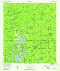 1943 Odessa1957 Print · USGSCoastal Florida pinelands and transit corridors emerge in this mid-century survey of the Pasco and Hillsborough county line. Trace the steam-era rail history through Odessa at the Atlantic Coast Line junction and explore the lakefronts of Keystone Lake and Camp Mawian.3 unique versions available
 - 1943 Map of Elfers, 1957 Print
 1943 Elfers1957 Print · USGSThe Florida Gulf Coast comes alive in the 1940s as settlements like New Port Richey and Tarpon Springs begin to take shape. Genealogists and researchers can trace the historic Dixie Highway and locate rural landmarks such as Elfers and Seven Springs.2 unique versions available
 - 1944 Map of Elfers
 1944 Elfers1944 Print · USGSThe Florida Gulf coast comes into focus during the mid-1940s as the communities of New Port Richey and Elfers begin to expand. Genealogists and local historians can trace family locations near Seven Springs, the Anclote River, and early rail lines like the Seaboard Air Line.
 - 1944 Map of Odessa
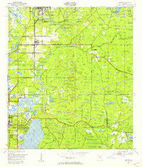
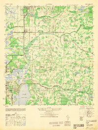
 1944 Odessa1944 Print · USGSMid-century Pasco and Hillsborough counties are shown here as a landscape of citrus groves, rail lines, and cypress swamps. Genealogists and historians can trace the footprint of early communities at Odessa and Lake Fern, or find landmarks like the Lake Fern School and Camp Mawian YMCA.
 - 1948 Map of Elfers
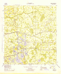
 1948 Elfers1948 Print · USGSThe Florida Gulf Coast near the Pasco and Pinellas border comes alive in this post-war survey. Genealogists and researchers can trace early settlements at New Port Richey, Elfers, and Seven Springs while following the Seaboard Air Line through the cypress swamps.
 - 1949 Map of Odessa
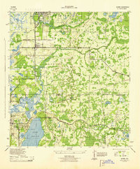
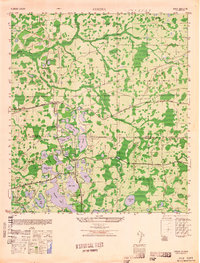 1949 Odessa1949 Print · USGSThe interior of the Florida Gulf Coast is shown here in the late 1940s, a landscape defined by citrus groves and sprawling lake networks. Genealogists and local historians can trace the early community hubs of Odessa and Lake Fern, including the Lake Fern School and the Atlantic Coast Line rail corridor.
End of results
Showing maps 1-6 of 6
Top cities near Trinity
- Tampa historical maps
- Clearwater historical maps
- Palm Harbor historical maps
- Dunedin historical maps
- East Lake historical maps
- Bayonet Point historical maps
See more
Top neighborhoods of Trinity
- Fox Hollow historical maps
- Spyglass historical maps
- Hampton Cove historical maps
- Bellerive historical maps
- Foxwood historical maps
Frequently asked questions
- What are the different types of historical maps available for Trinity?
- What is the oldest map of Trinity?
- Where can I purchase historical maps of Trinity for my home or office?
- Where can I download high-res historical maps of Trinity?
- Are there historical topographic maps available for Trinity?
- Is there historical aerial imagery available for Trinity?
- Where are historical maps of Trinity sourced from?