
1943 Map of Elfers
USGS Topo · Published 1957About this map
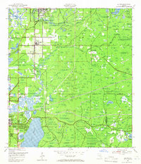
The Pithlachascotee River winds through the northern reaches of this coastal Florida landscape, marking a period of early development near New Port Richey and the community of Elfers. Surveyed in the early 1940s, the map illustrates a region defined by its complex hydrology, where the Anclote River and numerous sloughs like Duck Slough carve through the terrain toward Salt Lake and the massive expanse of Lake Tarpon. The transport network of the era is clearly visible, featuring the Seaboard Air Line Railroad and the historic Dixie Highway, alongside an Old Railroad Grade that hints at earlier industrial timber or transit routes.
Find a feature on this map
31 named features on this map. Tap any name to fly to it.
Don’t see what you’re looking for? This feature index may not catch every label — zoom into the map to look around manually.
Map Details
Editions of this 1943 Elfers Map
2 editions found
Other maps of this area

1943 · Dunedin
USGS Topo · 1:31,680

1943 · Tarpon Springs
USGS Topo · 1:31,680

1943 · Odessa
USGS Topo · 1:24,000

1943 · Oldsmar
USGS Topo · 1:24,000

1944 · Elfers
USGS Topo · 1:31,680

1944 · Oldsmar
USGS Topo · 1:31,680

1944 · Odessa
USGS Topo · 1:31,680
1947 · Citrus Park
USGS Topo · 1:24,000

1948 · Elfers
USGS Topo · 1:25,000

1949 · Odessa
USGS Topo · 1:25,000