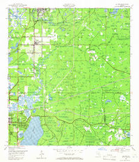
1943 Map of Elfers
USGS Topo · Published 1965About this map
Tarpon Springs and New Port Richey serve as the primary anchors for this mid-century coastal survey, reflecting a landscape defined by its intricate river systems and expanding rail infrastructure. The Anclote River and Pithlachascotee River wind through the terrain, featuring landmarks like Tokel Bend and Horseshoe Bend, while the expansive waters of Lake Tarpon dominate the southern portion of the sheet. The region's development during the early 1940s is traced through the parallel routes of the Atlantic Coast Line Railroad and the Seaboard Air Line Railroad, which facilitated the movement of goods and people between these growing Florida communities.
Find a feature on this map
32 named features on this map. Tap any name to fly to it.
Don’t see what you’re looking for? This feature index may not catch every label — zoom into the map to look around manually.
Map Details
Editions of this 1943 Elfers Map
2 editions found
Other maps of this area

1943 · Dunedin
USGS Topo · 1:31,680

1943 · Tarpon Springs
USGS Topo · 1:31,680

1943 · Odessa
USGS Topo · 1:24,000

1943 · Elfers
USGS Topo · 1:24,000

1943 · Oldsmar
USGS Topo · 1:24,000

1944 · Elfers
USGS Topo · 1:31,680

1944 · Oldsmar
USGS Topo · 1:31,680

1944 · Odessa
USGS Topo · 1:31,680
1947 · Citrus Park
USGS Topo · 1:24,000

1948 · Elfers
USGS Topo · 1:25,000