1940s Maps of Tarpon Springs, Florida
Explore 7 historic maps of Tarpon Springs from the 1940s. These maps offer a rare glimpse into what life looked like during the 1940s — showing old roads, neighborhoods, homes, and landmarks that have changed or disappeared over time.
Whether you're researching your family's past, planning a metal detecting trip, or studying how Tarpon Springs's landscape evolved across the 1940s, these high-resolution maps are a powerful tool for exploring the history of this region.
- Focus on a specific era: All maps on this page are from the 1940s, giving you a focused view of this time period.
- See what’s changed: Compare century-old streets, trails, and buildings to today's modern landscape using overlays and satellite layers.
- Research with precision: Use these maps for genealogy, historical research, land use analysis, or educational projects.
- View, download, or print: Maps are fully viewable online in high resolution, and can be downloaded or printed for your own records.
Start exploring Tarpon Springs's history through authentic maps from the 1940s. This is your window into the past.
Tarpon Springs, FL maps
(7)- 1943 Map of Dunedin
 1943 Dunedin1943 Print · USGSCoastal Pinellas County comes into focus during the early 1940s, documenting the shoreline from Dunedin north to Palm Harbor. Genealogists and historians can trace the Atlantic Coast Line railroad through small communities like Ozona, Wall Springs, and Crystal Beach.3 unique versions available
 - 1943 Map of Tarpon Springs
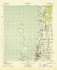
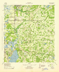
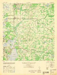
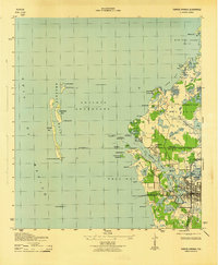 1943 Tarpon Springs1943 Print · USGSThe Gulf coast at the height of the war reveals a maritime landscape centered on the sponge docks and bayous. Researchers can trace the early layout of Tarpon Springs, the historic Anclote Keys Lighthouse, and old landmarks like Baileys Bluff.3 unique versions available
 - 1943 Map of Elfers, 1957 Print
 1943 Elfers1957 Print · USGSThe Florida Gulf Coast comes alive in the 1940s as settlements like New Port Richey and Tarpon Springs begin to take shape. Genealogists and researchers can trace the historic Dixie Highway and locate rural landmarks such as Elfers and Seven Springs.2 unique versions available
 - 1943 Map of Oldsmar, 1961 Print
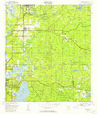
 1943 Oldsmar1961 Print · USGSUpper Pinellas County was a quiet region of citrus groves and coastal inlets during the early 1940s. Genealogists and historians can trace old community centers like Curlew, locate the Curlew Ch, and see the early layout of Oldsmar along the Seaboard Air Line railroad.2 unique versions available
 - 1944 Map of Elfers
 1944 Elfers1944 Print · USGSThe Florida Gulf coast comes into focus during the mid-1940s as the communities of New Port Richey and Elfers begin to expand. Genealogists and local historians can trace family locations near Seven Springs, the Anclote River, and early rail lines like the Seaboard Air Line.
 - 1944 Map of Oldsmar
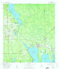
 1944 Oldsmar1944 Print · USGSCoastal Pinellas and Hillsborough counties are shown here during the Second World War as the region's citrus and rail economy began to meet modern highway expansion. Genealogists and local historians can locate early landmarks like Curlew Ch, the Indian Mounds, and the Seaboard Air Line corridor.
 - 1948 Map of Elfers
 1948 Elfers1948 Print · USGSThe Florida Gulf Coast near the Pasco and Pinellas border comes alive in this post-war survey. Genealogists and researchers can trace early settlements at New Port Richey, Elfers, and Seven Springs while following the Seaboard Air Line through the cypress swamps.
End of results
Showing maps 1-7 of 7
Top cities near Tarpon Springs
- Tampa historical maps
- Clearwater historical maps
- Largo historical maps
- Palm Harbor historical maps
- Dunedin historical maps
- East Lake historical maps
See more
Top neighborhoods of Tarpon Springs
- Windrush historical maps
- North Lake of Tarpon Springs historical maps
- Santos Isle Apartment Complex historical maps
- Parkside Colony historical maps
- The Villages at Tarpon historical maps
Frequently asked questions
- What are the different types of historical maps available for Tarpon Springs?
- What is the oldest map of Tarpon Springs?
- Where can I purchase historical maps of Tarpon Springs for my home or office?
- Where can I download high-res historical maps of Tarpon Springs?
- Are there historical topographic maps available for Tarpon Springs?
- Is there historical aerial imagery available for Tarpon Springs?
- Where are historical maps of Tarpon Springs sourced from?