1940s Maps of Interlachen, Florida
Explore 6 historic maps of Interlachen from the 1940s. These maps offer a rare glimpse into what life looked like during the 1940s — showing old roads, neighborhoods, homes, and landmarks that have changed or disappeared over time.
Whether you're researching your family's past, planning a metal detecting trip, or studying how Interlachen's landscape evolved across the 1940s, these high-resolution maps are a powerful tool for exploring the history of this region.
- Focus on a specific era: All maps on this page are from the 1940s, giving you a focused view of this time period.
- See what’s changed: Compare century-old streets, trails, and buildings to today's modern landscape using overlays and satellite layers.
- Research with precision: Use these maps for genealogy, historical research, land use analysis, or educational projects.
- View, download, or print: Maps are fully viewable online in high resolution, and can be downloaded or printed for your own records.
Start exploring Interlachen's history through authentic maps from the 1940s. This is your window into the past.
Interlachen, FL maps
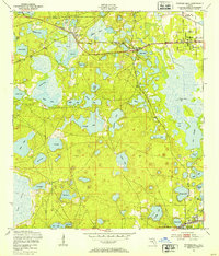
(6)- 1944 Map of Interlachen
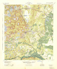 1944 Interlachen1944 Print · USGSNorth-central Florida's rail-and-water network is captured here in the 1940s, centered on the bustling junction at Interlachen. Genealogists and historians can trace riverside activity at Cedar Landing Ferry and early rural education sites like Congo Sch.
 - 1949 Map of Keuka, 1953 Print
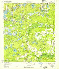 1949 Keuka1953 Print · USGSFlorida's lake country near the Marion and Putnam county line was a network of river landings and rail stops in the late 1940s. Genealogists and historians can trace community roots at Edgar Community Ch, find old crossings like Brumbridge Ferry, and locate early riverfront points at Agnews Landing.6 unique versions available
 - 1949 Map of Baywood, 1953 Print
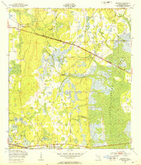 1949 Baywood1953 Print · USGSPutnam County in the late 1940s reveals a Florida landscape of cypress swamps and railway settlements. Researchers can trace family history at Mannville Cem or locate the early industry of Peat Cuttings near the Southern and Atlantic Coast Line railroads.3 unique versions available
 - 1949 Map of Rodman, 1953 Print
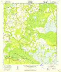 1949 Rodman1953 Print · USGSInland Florida in the late 1940s was a land of timber mills and riverfront landings. Trace the early boundaries of the Ocala National Forest and locate historical sites like Rainbow Ranch, Rodman, and the riverside Cedar Landing.3 unique versions available
 - 1949 Map of Putnam Hall, 1953 Print
 1949 Putnam Hall1953 Print · USGSThe lake-strewn interior of Putnam and Clay counties is captured here in the late 1940s, highlighting a landscape of rail-connected settlements. Genealogists and researchers can trace old trackside communities like Florahome, Putnam Hall, and Grandin along the Southern railroad line.3 unique versions available
 - 1949 Map of Interlachen, 1955 Print
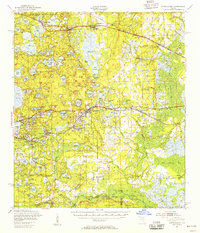 1949 Interlachen1955 Print · USGSPutnam County's lake-rich interior is captured here just after the war, showing the distinct citrus and rail-centered settlements of the era. Genealogists can locate family landmarks like Mt Bethel Ch, Johnson Park Sch, and the unique Peat Cuttings near Florahome.3 unique versions available
End of results
Showing maps 1-6 of 6
Top cities near Interlachen
- Palatka historical maps
- Citra historical maps
- Keystone Heights historical maps
- Hawthorne historical maps
- Welaka historical maps
- Island Grove historical maps
Frequently asked questions
- What are the different types of historical maps available for Interlachen?
- What is the oldest map of Interlachen?
- Where can I purchase historical maps of Interlachen for my home or office?
- Where can I download high-res historical maps of Interlachen?
- Are there historical topographic maps available for Interlachen?
- Is there historical aerial imagery available for Interlachen?
- Where are historical maps of Interlachen sourced from?