1960s Maps of Sumter County, Florida
Explore 14 historic maps of Sumter County from the 1960s. These maps offer a rare glimpse into what life looked like during the 1960s — showing old roads, neighborhoods, homes, and landmarks that have changed or disappeared over time.
Whether you're researching your family's past, planning a metal detecting trip, or studying how Sumter County's landscape evolved across the 1960s, these high-resolution maps are a powerful tool for exploring the history of this region.
- Focus on a specific era: All maps on this page are from the 1960s, giving you a focused view of this time period.
- See what’s changed: Compare century-old streets, trails, and buildings to today's modern landscape using overlays and satellite layers.
- Research with precision: Use these maps for genealogy, historical research, land use analysis, or educational projects.
- View, download, or print: Maps are fully viewable online in high resolution, and can be downloaded or printed for your own records.
Start exploring Sumter County's history through authentic maps from the 1960s. This is your window into the past.
Sumter County, FL maps
(14)- 1960 Map of Branchborough, 1962 Print
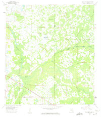 1960 Branchborough1962 Print · USGSThe swampy interior of Florida at the tri-county border shows a landscape of riverine hammocks and early forest industry in the 1960s. Genealogists and historians can trace the foundations of Branchborough and locate Withlacoochee Cemetery and Port Lonesome.4 unique versions available
 - 1960 Map of Bay Lake, 1962 Print
 1960 Bay Lake1962 Print · USGSFlorida's interior wetlands and timberlands are captured here in the early sixties, centered on the Sumter and Lake County border. Genealogists and historians can trace local landmarks like Bay Lake Ch or follow the path of the Seaboard Air Line through the cypress hammocks.3 unique versions available
 - 1960 Map of Rock Ridge, 1962 Print
 1960 Rock Ridge1962 Print · USGSThe Florida swamp country at the edge of Polk and Sumter Counties comes into focus during the early sixties. Genealogists and historians can trace the foundations of the Rock Ridge community, including Little Flock Ch and numerous segments of an Old Railroad Grade.4 unique versions available
 - 1960 Map of Clay Sink, 1962 Print
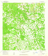
 1960 Clay Sink1962 Print · USGSFlorida's swampy interior at the Hernando and Pasco county line reveals a wilderness of forestry grades and isolated settlements in the early sixties. Researchers can trace the Atlantic Coast Line and locate sites like Bevels Place, Richloam, and Sturkey.2 unique versions available
 - 1962 Map of Orlando
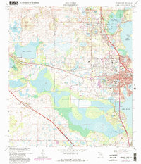
 1962 Orlando1962 Print · USGSCentral Florida was transformed by aerospace and citrus at the start of the sixties. Genealogists and historians can trace old community footprints from Eau Gallie to Leesburg, alongside landmarks like McCoy AFB and the winding Econlockhatchee River.
 - 1964 Map of Plant City
 1964 Plant City1964 Print · USGSThe West Florida coast and its interior rail corridors come alive in this mid-sixties survey, spanning from the gulf marshes to the agricultural heartland. Researchers can trace the routes of the Atlantic Coast Line through settlements like Bushnell, Inverness, and Plant City.
 - 1966 Map of Leesburg West
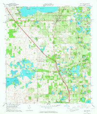
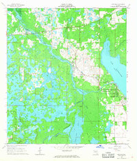
 1966 Leesburg West1966 Print · USGSMid-century Leesburg and Lake County are shown as the citrus groves and lakefronts began to welcome new residential growth. Genealogists and researchers can locate Lone Oak Cemetery, trace the Seaboard Coast Line, or find landmarks like Bugg Spring and Shiloh Ch.5 unique versions available
 - 1966 Map of Lady Lake, 1967 Print
 1966 Lady Lake1967 Print · USGSThe citrus-growing country between Lake and Marion counties comes into focus during the mid-sixties, centered on the growing community of Lady Lake. Researchers can trace local genealogy and land use through labels for Forest Hill Cem, Stanton Sch, and the Seaboard Coast Line railroad.4 unique versions available
 - 1966 Map of Oxford, 1968 Print
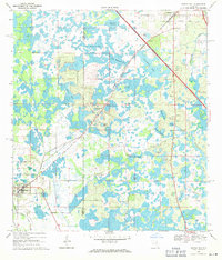
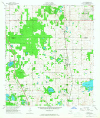 1966 Oxford1968 Print · USGSSumter and Marion County history comes alive in the mid-1960s, showing the early footprints of Orange Blossom Hills and the rural rail corridor. Trace family roots through Royal Memorial Cem, New Jerusalem Ch, or the small settlements of Pedro and Dallas.
 - 1966 Map of Lake Panasoffkee NW, 1968 Print
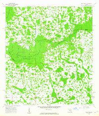
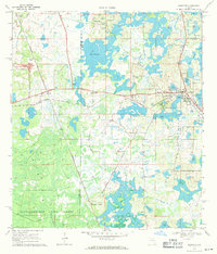
 1966 Lake Panasoffkee NW1968 Print · USGSThe wetlands of Sumter and Marion County were a complex maze of springs and swamps during the mid-1960s. Researchers can trace the Old Railroad Grade or locate the Nichols Cem and Gum Springs within this riverine landscape.4 unique versions available
 - 1967 Map of Rutland, 1968 Print
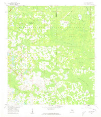
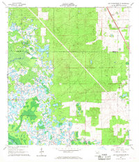
 1967 Rutland1968 Print · USGSSumter County was a labyrinth of wetlands and river bends in the late 1960s, dominated by the winding course of the Withlacoochee River. Genealogists and historians can trace old homesteads near Rutland, locate the Rutland Cem, or follow the path of an old Railroad Grade.2 unique versions available
 - 1967 Map of Wildwood, 1969 Print
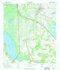 1967 Wildwood1969 Print · USGSSumter County transitions into the highway era in the late sixties as the new turnpike bisects established rail towns. Trace the growth of Wildwood and Coleman, or locate family landmarks like Oak Grove Cem and Adamsville.2 unique versions available
 - 1969 Map of Center Hill, 1971 Print
 1969 Center Hill1971 Print · USGSThe Sumter and Lake County line in the late sixties shows a landscape of expansive wetlands and developing infrastructure. Researchers can trace the path of the Seaboard Coast Line, locate Cool Spring Cem, and see the footprint of the University of Florida State Experimental Farm.
 - 1969 Map of Mascotte, 1971 Print
 1969 Mascotte1971 Print · USGSCentral Florida’s citrus and wetland corridor comes into focus in the late sixties, showing the rail-dependent growth of Mascotte and Groveland. Genealogists can trace rural life through landmarks like Midway Ch, Carters Island, and the Seaboard Coast Line.
End of results
Showing maps 1-14 of 14
Top cities of Sumter County
- The Villages historical maps
- Wildwood historical maps
- Bushnell historical maps
- Center Hill historical maps
- Webster historical maps
- Coleman historical maps
Frequently asked questions
- What are the different types of historical maps available for Sumter County?
- What is the oldest map of Sumter County?
- Where can I purchase historical maps of Sumter County for my home or office?
- Where can I download high-res historical maps of Sumter County?
- Are there historical topographic maps available for Sumter County?
- Is there historical aerial imagery available for Sumter County?
- Where are historical maps of Sumter County sourced from?