1960s Maps of Suwannee County, Florida
Explore 9 historic maps of Suwannee County from the 1960s. These maps offer a rare glimpse into what life looked like during the 1960s — showing old roads, neighborhoods, homes, and landmarks that have changed or disappeared over time.
Whether you're researching your family's past, planning a metal detecting trip, or studying how Suwannee County's landscape evolved across the 1960s, these high-resolution maps are a powerful tool for exploring the history of this region.
- Focus on a specific era: All maps on this page are from the 1960s, giving you a focused view of this time period.
- See what’s changed: Compare century-old streets, trails, and buildings to today's modern landscape using overlays and satellite layers.
- Research with precision: Use these maps for genealogy, historical research, land use analysis, or educational projects.
- View, download, or print: Maps are fully viewable online in high resolution, and can be downloaded or printed for your own records.
Start exploring Suwannee County's history through authentic maps from the 1960s. This is your window into the past.
Suwannee County, FL maps
(9)- 1961 Map of Live Oak East, 1962 Print
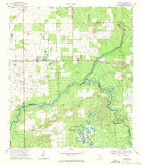
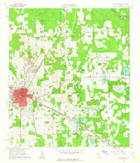 1961 Live Oak East1962 Print · USGSSuwannee County was a major rail and industrial crossroads in the early sixties, centered on the hub of Live Oak. Local historians can trace the intersecting lines of the Southern Railway and find landmarks like the Suwannee Mine and Douglas High Sch.2 unique versions available
 - 1961 Map of Hillcoat, 1963 Print
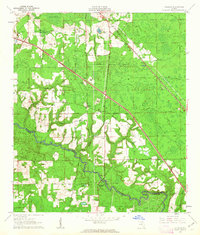 1961 Hillcoat1963 Print · USGSNorth Florida's river country is captured here in the early sixties, showing the intersection of heavy rail and rural settlement along the river. Genealogists can locate family landmarks like Nunn Cem and Mt Pleasant Ch near the historic Suwannee Springs.2 unique versions available
 - 1961 Map of White Springs West, 1963 Print
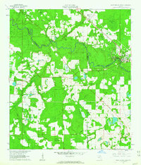 1961 White Springs West1963 Print · USGSThe Suwannee River country in the early sixties was a landscape of river-bend memorials and rural church communities. Genealogists can trace family footprints at Springville Ch or Swift Creek Cem, and locate landmarks like the Sailor Hotel and Bullock Lookout Tower.3 unique versions available
 - 1968 Map of Branford, 1971 Print
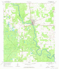 1968 Branford1971 Print · USGSThe Suwannee River country in the late 1960s comes alive in this survey of the river's junction with the Santa Fe. Researchers can trace the rail lines of the Seaboard Coast Line and locate historic sites like Mt Paran Ch and Hunts Cem.3 unique versions available
 - 1968 Map of Hildreth, 1971 Print
 1968 Hildreth1971 Print · USGSThe rural river junction where the Suwannee River meets the Santa Fe River is captured here during the late sixties. Researchers can find long-standing community sites such as Santa Fe Cem Ch and the springhead at Ichetucknee Springs.4 unique versions available
 - 1969 Map of Wellborn, 1971 Print
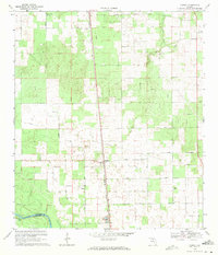
 1969 Wellborn1971 Print · USGSThe Suwannee County countryside comes into focus during the late sixties, centered on the railroad town of Wellborn. Researchers can trace rural lineages through family landmarks like McClellan Cem and isolated country churches such as Mt Beulah Ch.
 - 1969 Map of O'Brien, 1971 Print
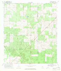
 1969 O'Brien1971 Print · USGSSuwannee County in the late sixties centers on the railroad hamlet of O'Brien and its surrounding network of country churches. Genealogists can trace family landmarks and burial sites like Cedar Grove Cem, Mt Zion Ch, and Pleasant Hill Ch across this river-fed landscape.3 unique versions available
 - 1969 Map of O'Brien SE, 1971 Print
 1969 O'Brien SE1971 Print · USGSSuwannee and Columbia counties are captured during a period of rural agricultural development in the late sixties. Genealogists and local historians can locate community centers like Philadelphia Ch and Evergreen Ch or trace old routes such as Troy Road.3 unique versions available
 - 1969 Map of McAlpin, 1971 Print
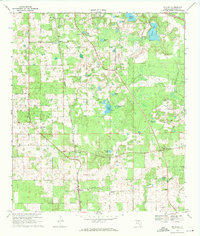 1969 McAlpin1971 Print · USGSSuwannee County remains a rural agricultural landscape in the late sixties, centered on the rail-fed community of McAlpin. Genealogists and local historians can locate country landmarks like Beulah Hill Ch, Bethlehem Cem, and the Rocky Hill Lookout Tower.3 unique versions available
End of results
Showing maps 1-9 of 9
Top cities of Suwannee County
Frequently asked questions
- What are the different types of historical maps available for Suwannee County?
- What is the oldest map of Suwannee County?
- Where can I purchase historical maps of Suwannee County for my home or office?
- Where can I download high-res historical maps of Suwannee County?
- Are there historical topographic maps available for Suwannee County?
- Is there historical aerial imagery available for Suwannee County?
- Where are historical maps of Suwannee County sourced from?