1940s Maps of Pennichaw, Florida
Explore 1 historic maps of Pennichaw from the 1940s. These maps offer a rare glimpse into what life looked like during the 1940s — showing old roads, neighborhoods, homes, and landmarks that have changed or disappeared over time.
Whether you're researching your family's past, planning a metal detecting trip, or studying how Pennichaw's landscape evolved across the 1940s, these high-resolution maps are a powerful tool for exploring the history of this region.
- Focus on a specific era: All maps on this page are from the 1940s, giving you a focused view of this time period.
- See what’s changed: Compare century-old streets, trails, and buildings to today's modern landscape using overlays and satellite layers.
- Research with precision: Use these maps for genealogy, historical research, land use analysis, or educational projects.
- View, download, or print: Maps are fully viewable online in high resolution, and can be downloaded or printed for your own records.
Start exploring Pennichaw's history through authentic maps from the 1940s. This is your window into the past.
Pennichaw, FL maps
(1)- 1949 Map of Osceola, 1983 Print
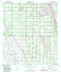 1949 Osceola1983 Print · USGSAlong the Florida coastline in the late 1940s, the citrus groves and nascent residential tracks of the Atlantic shore were beginning to transform. Researchers can trace the early footprints of Vero Beach, locate the McKee Jungle Gardens, and follow the Florida East Coast railway through Oslo.
End of results
Showing maps 1-1 of 1
Top cities near Pennichaw
- Orlando historical maps
- Deltona historical maps
- Sanford historical maps
- Titusville historical maps
- Oviedo historical maps
- Edgewater historical maps
See more
Frequently asked questions
- What are the different types of historical maps available for Pennichaw?
- What is the oldest map of Pennichaw?
- Where can I purchase historical maps of Pennichaw for my home or office?
- Where can I download high-res historical maps of Pennichaw?
- Are there historical topographic maps available for Pennichaw?
- Is there historical aerial imagery available for Pennichaw?
- Where are historical maps of Pennichaw sourced from?