1980s Maps of Walton County, Florida
Explore 11 historic maps of Walton County from the 1980s. These maps offer a rare glimpse into what life looked like during the 1980s — showing old roads, neighborhoods, homes, and landmarks that have changed or disappeared over time.
Whether you're researching your family's past, planning a metal detecting trip, or studying how Walton County's landscape evolved across the 1980s, these high-resolution maps are a powerful tool for exploring the history of this region.
- Focus on a specific era: All maps on this page are from the 1980s, giving you a focused view of this time period.
- See what’s changed: Compare century-old streets, trails, and buildings to today's modern landscape using overlays and satellite layers.
- Research with precision: Use these maps for genealogy, historical research, land use analysis, or educational projects.
- View, download, or print: Maps are fully viewable online in high resolution, and can be downloaded or printed for your own records.
Start exploring Walton County's history through authentic maps from the 1980s. This is your window into the past.
Walton County, FL maps
(11)- 1981 Map of Panama City
 1981 Panama City1981 Print · USGSPanama City and the Florida Panhandle coast are captured here in the early eighties, showing the region's balance of military installations and maritime industry. Researchers can trace the Atlanta and St Andrews Bay RR or locate coastal sites like Tyndall Air Force Base and Dead Lake.2 unique versions available
 - 1982 Map of Hinsons Crossroads
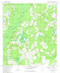 1982 Hinsons Crossroads1982 Print · USGSThe Florida Panhandle's riverine landscape is meticulously documented here during the early eighties, centered on the Choctawhatchee River. Genealogists can locate family-named landmarks like Cooey Field and rural churches including New Bethany Ch and St Matthews Cem Ch.
 - 1982 Map of Millers Ferry, 1983 Print
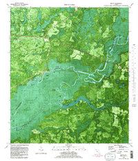
 1982 Millers Ferry1983 Print · USGSThe Florida Panhandle's riverine landscape is captured here in the late seventies, showing the rural communities along Holmes Creek. Genealogists can locate family sites like Weeks Cem and historic country churches including St Johns Ch and Liberty Ch.
 - 1982 Map of Seminole Hills, 1983 Print
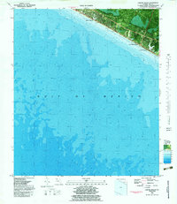
 1982 Seminole Hills1983 Print · USGSThe Florida Panhandle coast near the Walton and Bay County line comes into focus in the early eighties as beachfront communities begin to expand. Trace the shifting shoreline at Philips Inlet or locate landmarks like Powell Lake and Hollywood Beach.
 - 1982 Map of Laguna Beach, 1983 Print
 1982 Laguna Beach1983 Print · USGSThe Florida Panhandle coastline is documented in the early eighties as beach communities began to expand along the emerald waters. Genealogists and local historians can trace the early footprints of Laguna Beach, Gulf Resort Beach, and Lullwater Beach.
 - 1982 Map of Bruce, 1983 Print
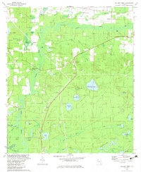
 1982 Bruce1983 Print · USGSThe Choctawhatchee River floodplain in the early eighties reveals a complex landscape of wetlands and timberland at the meeting of Walton, Washington, and Bay counties. Genealogists and local historians can trace family-named sites like Gunlock Cem, Miller Landing, and the settlement of Bruce.2 unique versions available
 - 1982 Map of Redbay, 1983 Print
 1982 Redbay1983 Print · USGSThe Choctawhatchee River bottomlands and the settlement of Redbay are captured here in the early eighties. Researchers can trace local history through the Antioch Cem, identify old river landings like Story Landing, and locate family landmarks such as McKinnon Hill.
 - 1982 Map of Ponce De Leon, 1983 Print
 1982 Ponce De Leon1983 Print · USGSThe Florida Panhandle comes into focus in the early eighties as a network of rural settlements and timberlands. Genealogists and researchers can trace local roots through numerous country landmarks including Knox Hill, Andrew Chapel, and Hardy Cem.2 unique versions available
 - 1982 Map of Red Head, 1983 Print
 1982 Red Head1983 Print · USGSThe Florida Panhandle's tri-county borderlands are revealed in the early 1980s, showcasing the intersection of river, forest, and small-town life. Researchers can locate family landmarks like Oak Grove Ch, the Red Head settlement, and various backcountry water bodies such as Court Martial Lake.
 - 1987 Map of Darlington, 1993 Print
 1987 Darlington1993 Print · USGSIn the late twentieth century, this North Florida borderland was a patchwork of small communities and family-named cemeteries. Researchers can trace rural settlement patterns through sites like the Limestone Cem, the village of Darlington, and the wetlands of Peavey Bay.
 - 1988 Map of Tallahassee
 1988 Tallahassee1988 Print · USGSThe Florida Panhandle and South Georgia are captured here in the late eighties, showing the expansion of the regional highway network and coastal growth. Genealogists and historians can trace rail lines like the Seaboard System Railroad or locate family roots in Blountstown, Graceville, or Crawfordville.2 unique versions available
End of results
Showing maps 1-11 of 11
Top cities of Walton County
- Santa Rosa Beach historical maps
- Miramar Beach historical maps
- DeFuniak Springs historical maps
- Freeport historical maps
- Paxton historical maps
Frequently asked questions
- What are the different types of historical maps available for Walton County?
- What is the oldest map of Walton County?
- Where can I purchase historical maps of Walton County for my home or office?
- Where can I download high-res historical maps of Walton County?
- Are there historical topographic maps available for Walton County?
- Is there historical aerial imagery available for Walton County?
- Where are historical maps of Walton County sourced from?