1930s Maps of Walton County, Florida
Explore 8 historic maps of Walton County from the 1930s. These maps offer a rare glimpse into what life looked like during the 1930s — showing old roads, neighborhoods, homes, and landmarks that have changed or disappeared over time.
Whether you're researching your family's past, planning a metal detecting trip, or studying how Walton County's landscape evolved across the 1930s, these high-resolution maps are a powerful tool for exploring the history of this region.
- Focus on a specific era: All maps on this page are from the 1930s, giving you a focused view of this time period.
- See what’s changed: Compare century-old streets, trails, and buildings to today's modern landscape using overlays and satellite layers.
- Research with precision: Use these maps for genealogy, historical research, land use analysis, or educational projects.
- View, download, or print: Maps are fully viewable online in high resolution, and can be downloaded or printed for your own records.
Start exploring Walton County's history through authentic maps from the 1930s. This is your window into the past.
Walton County, FL maps
(8)- 1934 Map of Niceville
 1934 Niceville1934 Print · USGSThe Florida Panhandle in the mid-thirties reveals a landscape of tidal bayous and managed pine forests. Researchers can trace early infrastructure like the Bolton Turpentine Still, State Convict Camp No 12, and the path of the Old Spanish Trail.
 - 1935 Map of Villa Tasso
 1935 Villa Tasso1935 Print · USGSThe Florida Panhandle's coast appears here in the mid-1930s, showing a landscape of federal forests and burgeoning recreation. You can trace early sites like Postls Resort, the State 4H Club Camp, and the extensive Moreno Point Military Reservation.
 - 1935 Map of De Funiak Springs
 1935 De Funiak Springs1935 Print · USGSWalton County in the mid-1930s shows a landscape of rural schools and family homesteads centered around the rail hub of De Funiak Springs. Genealogists can trace family locations near Magnolia Cem, Seckinger Mill, and the many one-room schoolhouses like Indian Head Sch.2 unique versions available
 - 1936 Map of Niceville
 1936 Niceville1936 Print · USGSThe Okaloosa and Walton County line area is documented here in the mid-1930s, showing the transition from northern rail towns to coastal settlements. You can trace early family landmarks and infrastructure like Early Cem, Spencer Flats, and the Ramer Lookout Tower.4 unique versions available
 - 1936 Map of Point Washington
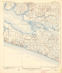
 1936 Point Washington1936 Print · USGSCoastal Walton County in the mid-1930s reveals a maritime landscape defined by river deltas and emerging beach communities. Genealogists and historians can trace the early footprints of Seagrove Beach and Point Washington, or locate the Bunker Cem and Pt. Washington Light House.2 unique versions available
 - 1938 Map of Villa Tasso
 1938 Villa Tasso1938 Print · USGSChoctawhatchee Bay and the Emerald Coast appear here in the mid-1930s, showing a landscape defined by military land and national forest. Trace early development in Valparaiso or follow the Gulf Coast Highway past coastal gems like Stewart Lake and Topsail Hill.4 unique versions available
 - 1938 Map of De Funiak Springs
 1938 De Funiak Springs1938 Print · USGSWalton County in the late thirties is a landscape of creek-side mills and timberlands stretching from the Louisville and Nashville RR down to the bay. Genealogists can locate family landmarks like Oak Ridge Cem, trace old routes at Old Walton Bridge, and find rural school sites like Eucheanna Sch.4 unique versions available
 - 1939 Map of Point Washington
 1939 Point Washington1939 Print · USGSThe Florida Panhandle coast near Walton County shows its quiet pre-development character during the late 1930s. Genealogists and local historians can trace the foundations of early beach settlements at Grayton Beach and Point Washington, or locate the Liberty Sch and Black Creek Chs inland.3 unique versions available
End of results
Showing maps 1-8 of 8
Top cities of Walton County
- Santa Rosa Beach historical maps
- Miramar Beach historical maps
- DeFuniak Springs historical maps
- Freeport historical maps
- Paxton historical maps
Frequently asked questions
- What are the different types of historical maps available for Walton County?
- What is the oldest map of Walton County?
- Where can I purchase historical maps of Walton County for my home or office?
- Where can I download high-res historical maps of Walton County?
- Are there historical topographic maps available for Walton County?
- Is there historical aerial imagery available for Walton County?
- Where are historical maps of Walton County sourced from?