1990s Maps of Walton County, Florida
Explore 6 historic maps of Walton County from the 1990s. These maps offer a rare glimpse into what life looked like during the 1990s — showing old roads, neighborhoods, homes, and landmarks that have changed or disappeared over time.
Whether you're researching your family's past, planning a metal detecting trip, or studying how Walton County's landscape evolved across the 1990s, these high-resolution maps are a powerful tool for exploring the history of this region.
- Focus on a specific era: All maps on this page are from the 1990s, giving you a focused view of this time period.
- See what’s changed: Compare century-old streets, trails, and buildings to today's modern landscape using overlays and satellite layers.
- Research with precision: Use these maps for genealogy, historical research, land use analysis, or educational projects.
- View, download, or print: Maps are fully viewable online in high resolution, and can be downloaded or printed for your own records.
Start exploring Walton County's history through authentic maps from the 1990s. This is your window into the past.
Walton County, FL maps
(6)- 1994 Map of Ponce De Leon, 1998 Print
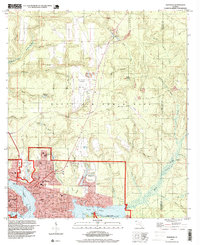
 1994 Ponce De Leon1998 Print · USGSWalton County in the mid-1990s remained a landscape of spring-fed waters and rural crossroads before the rapid growth of the modern era. Genealogists and local historians can trace family landmarks like Knox Hill, Douglass Crossroads, and Beech Grove Ch.
 - 1994 Map of Red Head, 1998 Print
 1994 Red Head1998 Print · USGSThe Florida panhandle comes into focus during the mid-1990s, showcasing the rural landscapes of Bay County. Genealogists and researchers can trace the vicinity of Red Head and the winding course of the Choctawhatchee River.
 - 1994 Map of Choctaw Beach, 1999 Print
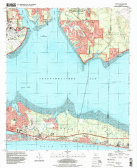
 1994 Choctaw Beach1999 Print · USGSChoctawhatchee Bay and the Walton County coastline appear here during the mid-nineties, showing the intersection of military, state, and private lands. You can trace the development of Choctaw Beach and the shores of Hogtown Bayou or find secluded spots like Fuller Lake.
 - 1994 Map of Destin, 1999 Print
 1994 Destin1999 Print · USGSChoctawhatchee Bay and the Emerald Coast appear here as they were in the mid-1990s, when tourism and military operations shaped the landscape. Genealogists and historians can trace the development of Destin, locate the Destin Sch, and explore the northern settlements of Niceville and Seminole.
 - 1994 Map of Niceville, 1999 Print
 1994 Niceville1999 Print · USGSCoastal Okaloosa County is shown in the mid-1990s as the communities of Niceville and Valparaiso expanded around the bayous. Researchers can find local landmarks like Okaloosa Walton Jr College, Sunset Cem, and the Pinecrest Community.
 - 1996 Map of Point Washington
 1996 Point Washington1996 Print · USGSThe Walton County coast and Choctawhatchee delta are shown here in the mid-nineties as the beach communities began to expand. Trace the intricate river channels near Opossum Island or locate established landmarks like Point Washington and Grayton Beach State Park.
End of results
Showing maps 1-6 of 6
Top cities of Walton County
- Santa Rosa Beach historical maps
- Miramar Beach historical maps
- DeFuniak Springs historical maps
- Freeport historical maps
- Paxton historical maps
Frequently asked questions
- What are the different types of historical maps available for Walton County?
- What is the oldest map of Walton County?
- Where can I purchase historical maps of Walton County for my home or office?
- Where can I download high-res historical maps of Walton County?
- Are there historical topographic maps available for Walton County?
- Is there historical aerial imagery available for Walton County?
- Where are historical maps of Walton County sourced from?