1950s Maps of Walton County, Florida
Explore 12 historic maps of Walton County from the 1950s. These maps offer a rare glimpse into what life looked like during the 1950s — showing old roads, neighborhoods, homes, and landmarks that have changed or disappeared over time.
Whether you're researching your family's past, planning a metal detecting trip, or studying how Walton County's landscape evolved across the 1950s, these high-resolution maps are a powerful tool for exploring the history of this region.
- Focus on a specific era: All maps on this page are from the 1950s, giving you a focused view of this time period.
- See what’s changed: Compare century-old streets, trails, and buildings to today's modern landscape using overlays and satellite layers.
- Research with precision: Use these maps for genealogy, historical research, land use analysis, or educational projects.
- View, download, or print: Maps are fully viewable online in high resolution, and can be downloaded or printed for your own records.
Start exploring Walton County's history through authentic maps from the 1950s. This is your window into the past.
Walton County, FL maps
(12)- 1950 Map of Millers Ferry
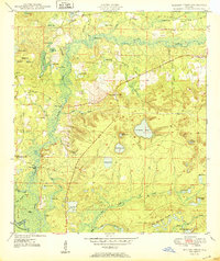 1950 Millers Ferry1950 Print · USGSThe riverine corridor of the Florida Panhandle comes alive in the mid-century before major highway changes altered the local landscape. Genealogists can trace family connections at Miller Cem and locate vanished river crossings like Millers Ferry and Shell Landing Ferry.
 - 1950 Map of Laurel Hill
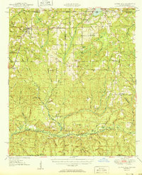 1950 Laurel Hill1950 Print · USGSThe Florida-Alabama border region is captured here at mid-century, showcasing the timberlands and rail-centered settlements between Laurel Hill and Florala. Researchers can trace old transportation routes like the Old Spanish Trail and find family sites like Mt Zion Cem or Dorcas Ch.2 unique versions available
 - 1950 Map of Ponce De Leon
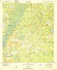
 1950 Ponce De Leon1950 Print · USGSFlorida's Panhandle is captured here at mid-century, where the Louisville and Nashville railroad meets the winding Choctawhatchee River. Researchers can locate old community landmarks like Douglas Crossroad, Knox Hill Sch, and the historic Old Spanish Trail.
 - 1950 Map of Hinsons Cross Roads
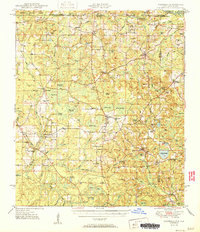
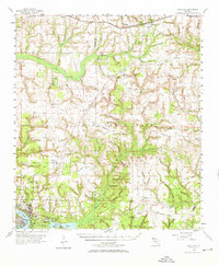
 1950 Hinsons Cross Roads1950 Print · USGSFlorida's Panhandle is documented here at the midpoint of the century, showing the rural intersections of Washington, Holmes, and Walton counties. Genealogists can trace local landmarks like St Matthews Ch, Clarkston Cem, and the community at Hinsons Cross Roads.
 - 1950 Map of Redbay
 1950 Redbay1950 Print · USGSThe Choctawhatchee River corridor in the mid-century remains a landscape of dense swamps and small upland settlements. Local researchers can trace family landmarks and burial sites like Redbay Cem, Dead River Cem, and the river landing at Story Landing.
 - 1951 Map of Glendale
 1951 Glendale1951 Print · USGSThe Alabama-Florida borderlands come to life in this mid-century survey of the pine-studded interior. Genealogists and local historians can trace family-named landmarks like Braxton Cem and old community hubs including Gaskin, Glendale, and Limestone Ch.2 unique versions available
 - 1954 Map of Tallahassee, 1967 Print
 1954 Tallahassee1967 Print · USGSThe Florida Panhandle and South Georgia are captured here during a period of mid-century growth and military expansion. Researchers can trace the development of Panama City, the footprint of Tyndall Air Force Base, and the rail lines of the Atlantic Coast Line.4 unique versions available
 - 1956 Map of Niceville
 1956 Niceville1956 Print · USGSCoastal Okaloosa and Walton Counties are shown in the mid-fifties as the military and aviation presence expanded around the Choctawhatchee Bay. Genealogists and historians can locate early airstrips like Pierce Field, the rail stop at Deerland, and local landmarks like Mt Sinai Ch.3 unique versions available
 - 1956 Map of Villa Tasso, 1958 Print
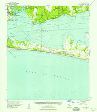 1956 Villa Tasso1958 Print · USGSCoastal Walton and Okaloosa counties appear in the mid-fifties, showing the peninsula and bay before the rise of modern high-rise development. Genealogists and local historians can trace the early layout of Destin and find isolated landmarks like Villa Tasso, Topsail Hill, and the Destin School.2 unique versions available
 - 1957 Map of Pensacola, 1967 Print
 1957 Pensacola1967 Print · USGSThe Florida Panhandle and Alabama coast are seen here at the height of the Cold War, showcasing a unique mix of military aviation and emerging beach tourism. Genealogists and local historians can trace legacy sites like Old Corry Field, the lumber town of Bagdad, and the coastal reaches of Santa Rosa Island.3 unique versions available
 - 1959 Map of Tallahassee
 1959 Tallahassee1959 Print · USGSFlorida's Panhandle and the Big Bend region appear here in the mid-fifties, showing a landscape defined by its great river systems and developing coast. Trace the early layout of Panama City, the expansive Apalachicola National Forest, and the coastal St Marks Lighthouse.
 - 1959 Map of Pensacola
 1959 Pensacola1959 Print · USGSThe Florida Panhandle and Alabama coast come alive in this late fifties survey of military aviation and maritime life. Genealogists can trace family roots in Bagdad, Loxley, and Milton while mapping the rails of the Louisville and Nashville.
End of results
Showing maps 1-12 of 12
Top cities of Walton County
- Santa Rosa Beach historical maps
- Miramar Beach historical maps
- DeFuniak Springs historical maps
- Freeport historical maps
- Paxton historical maps
Frequently asked questions
- What are the different types of historical maps available for Walton County?
- What is the oldest map of Walton County?
- Where can I purchase historical maps of Walton County for my home or office?
- Where can I download high-res historical maps of Walton County?
- Are there historical topographic maps available for Walton County?
- Is there historical aerial imagery available for Walton County?
- Where are historical maps of Walton County sourced from?