1970s Maps of Mossy Head, Florida
Explore 2 historic maps of Mossy Head from the 1970s. These maps offer a rare glimpse into what life looked like during the 1970s — showing old roads, neighborhoods, homes, and landmarks that have changed or disappeared over time.
Whether you're researching your family's past, planning a metal detecting trip, or studying how Mossy Head's landscape evolved across the 1970s, these high-resolution maps are a powerful tool for exploring the history of this region.
- Focus on a specific era: All maps on this page are from the 1970s, giving you a focused view of this time period.
- See what’s changed: Compare century-old streets, trails, and buildings to today's modern landscape using overlays and satellite layers.
- Research with precision: Use these maps for genealogy, historical research, land use analysis, or educational projects.
- View, download, or print: Maps are fully viewable online in high resolution, and can be downloaded or printed for your own records.
Start exploring Mossy Head's history through authentic maps from the 1970s. This is your window into the past.
Mossy Head, FL maps
(2)- 1973 Map of Mossy Head, 1976 Print
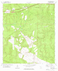 1973 Mossy Head1976 Print · USGSWalton County's interior was a landscape of military aviation and railroad transit during the mid-seventies. Genealogists and historians can trace the development of Mossy Head and the expansive reach of Eglin Air Force Base near Mt Sinai and Auxiliary Field No 1.2 unique versions available
 - 1978 Map of Crestview, 1982 Print
 1978 Crestview1982 Print · USGSThe Florida Panhandle and southern Alabama borderlands appear here in the late seventies as the military and timber industries shaped the landscape. Genealogists can trace family roots through small settlements like Cannon Town or Svea, and locate old sites like Aux Field No 4 (Abandoned).2 unique versions available
End of results
Showing maps 1-2 of 2
Top cities near Mossy Head
- Crestview historical maps
- Valparaiso historical maps
- DeFuniak Springs historical maps
- Freeport historical maps
- Paxton historical maps
- Laurel Hill historical maps
Frequently asked questions
- What are the different types of historical maps available for Mossy Head?
- What is the oldest map of Mossy Head?
- Where can I purchase historical maps of Mossy Head for my home or office?
- Where can I download high-res historical maps of Mossy Head?
- Are there historical topographic maps available for Mossy Head?
- Is there historical aerial imagery available for Mossy Head?
- Where are historical maps of Mossy Head sourced from?