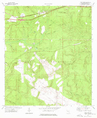
1973 Map of Mossy Head
USGS Topo · Published 1976About this map
Mossy Head serves as the primary settlement hub in this Walton County landscape, positioned along the critical transit corridor of the Louisville and Nashville Railroad. The 1970s terrain is heavily influenced by the presence of Eglin Air Force Base, which encompasses a significant portion of the southern territory. This military infrastructure includes specialized features such as Auxiliary Field No 1 and a dedicated U.S. Government Railroad spur cutting through the timbered uplands toward the base interior.
Find a feature on this map
42 named features on this map. Tap any name to fly to it.
Don’t see what you’re looking for? This feature index may not catch every label — zoom into the map to look around manually.
Map Details
Editions of this 1973 Mossy Head Map
2 editions found
Other maps of this area

1934 · Niceville
USGS Topo · 1:48,000

1935 · De Funiak Springs
USGS Topo · 1:48,000

1936 · Niceville
USGS Topo · 1:62,500

1938 · De Funiak Springs
USGS Topo · 1:62,500

1949 · Glendale
USGS Topo · 1:62,500

1949 · Laurel Hill
USGS Topo · 1:62,500

1950 · Laurel Hill
USGS Topo · 1:62,500

1951 · Glendale
USGS Topo · 1:62,500

1956 · Niceville
USGS Topo · 1:62,500

1957 · Pensacola
USGS Topo · 1:250,000