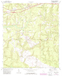
1973 Map of Mossy Head
USGS Topo · Published 1987About this map
The settlement of Mossy Head serves as the focal point for this section of Walton County, situated along the CSX rail line and Interstate 10. To the south, the landscape is defined by the massive footprint of Eglin Air Force Base, which contains critical military infrastructure including Auxiliary Field No 1 and the U. S. Government Railroad. This military presence is interwoven with the natural hydrology of the Florida panhandle, where numerous headwaters like Titi Creek and Exline Creek carve through the terrain. Notable local elevations such as Mt Sinai and Sandy Mountain rise above the dense network of branches and creeks. The 1987 revisions, shown in purple, highlight the growth of transportation and utility corridors, while numerous sandpits indicate the local extractive industry that supported development in this era.
Find a feature on this map
41 named features on this map. Tap any name to fly to it.
Don’t see what you’re looking for? This feature index may not catch every label — zoom into the map to look around manually.
Map Details
Editions of this 1973 Mossy Head Map
2 editions found
Other maps of this area

1934 · Niceville
USGS Topo · 1:48,000

1935 · De Funiak Springs
USGS Topo · 1:48,000

1936 · Niceville
USGS Topo · 1:62,500

1938 · De Funiak Springs
USGS Topo · 1:62,500

1949 · Glendale
USGS Topo · 1:62,500

1949 · Laurel Hill
USGS Topo · 1:62,500

1950 · Laurel Hill
USGS Topo · 1:62,500

1951 · Glendale
USGS Topo · 1:62,500

1956 · Niceville
USGS Topo · 1:62,500

1957 · Pensacola
USGS Topo · 1:250,000