1970s Maps of Baxley, Georgia
Explore 5 historic maps of Baxley from the 1970s. These maps offer a rare glimpse into what life looked like during the 1970s — showing old roads, neighborhoods, homes, and landmarks that have changed or disappeared over time.
Whether you're researching your family's past, planning a metal detecting trip, or studying how Baxley's landscape evolved across the 1970s, these high-resolution maps are a powerful tool for exploring the history of this region.
- Focus on a specific era: All maps on this page are from the 1970s, giving you a focused view of this time period.
- See what’s changed: Compare century-old streets, trails, and buildings to today's modern landscape using overlays and satellite layers.
- Research with precision: Use these maps for genealogy, historical research, land use analysis, or educational projects.
- View, download, or print: Maps are fully viewable online in high resolution, and can be downloaded or printed for your own records.
Start exploring Baxley's history through authentic maps from the 1970s. This is your window into the past.
Baxley, GA maps
(5)- 1970 Map of Pine Grove, 1974 Print
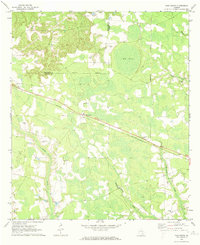 1970 Pine Grove1974 Print · USGSAppling and Jeff Davis counties are captured here in the early seventies, dominated by the timber and rail landscape of South Georgia. Researchers can trace the path of the Southern railway through Pine Grove and locate rural landmarks like Sellers Cem or Big Oak Ch.2 unique versions available
 - 1970 Map of Baxley, 1974 Print
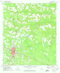 1970 Baxley1974 Print · USGSBaxley and the rural stretches of Appling County are captured here in the early seventies as the town served as a vital rail and civic hub. Genealogists and local historians can trace family-named sites like Sellers Cem and Carter Cem, or locate rural landmarks like Tenmile Ch and the Drive-in Theater.2 unique versions available
 - 1971 Map of Alma NW, 1974 Print
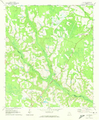 1971 Alma NW1974 Print · USGSAppling and Bacon counties are shown here in the early 1970s, defined by the winding course of Big Satilla Creek. Genealogists and local historians can locate rural landmarks like Dyals Sch, New Hope Ch, and the Big Creek Ch Cem.
 - 1971 Map of Alma NE, 1974 Print
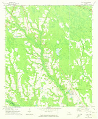 1971 Alma NE1974 Print · USGSThe rural borderlands of Appling and Bacon County are captured here in the early seventies as small farms and family tracts predominated. Genealogists can trace family lines through the Old Pleasant Grove Cem, Carter Cem, and the Odum Childrens Home.
 - 1979 Map of Hazlehurst, 1980 Print
 1979 Hazlehurst1980 Print · USGSSoutheast Georgia in the late seventies is defined by the convergence of major rail lines and river basins in Jeff Davis and Appling counties. Genealogists and local historians can trace the development of Hazlehurst and Baxley alongside features like the Pine Grove Pipeline and the Altamaha River wetlands.
End of results
Showing maps 1-5 of 5
Top cities near Baxley
Top neighborhoods of Baxley
- Bassville historical maps
- Cannafax Mobile Home Park historical maps
- Holt Homes historical maps
- Speer Homes historical maps
- Weatherly Park historical maps
- Pine Forest historical maps
See more
Frequently asked questions
- What are the different types of historical maps available for Baxley?
- What is the oldest map of Baxley?
- Where can I purchase historical maps of Baxley for my home or office?
- Where can I download high-res historical maps of Baxley?
- Are there historical topographic maps available for Baxley?
- Is there historical aerial imagery available for Baxley?
- Where are historical maps of Baxley sourced from?