1990s Maps of Athens, Georgia
Explore 2 historic maps of Athens from the 1990s. These maps offer a rare glimpse into what life looked like during the 1990s — showing old roads, neighborhoods, homes, and landmarks that have changed or disappeared over time.
Whether you're researching your family's past, planning a metal detecting trip, or studying how Athens's landscape evolved across the 1990s, these high-resolution maps are a powerful tool for exploring the history of this region.
- Focus on a specific era: All maps on this page are from the 1990s, giving you a focused view of this time period.
- See what’s changed: Compare century-old streets, trails, and buildings to today's modern landscape using overlays and satellite layers.
- Research with precision: Use these maps for genealogy, historical research, land use analysis, or educational projects.
- View, download, or print: Maps are fully viewable online in high resolution, and can be downloaded or printed for your own records.
Start exploring Athens's history through authentic maps from the 1990s. This is your window into the past.
Athens, GA maps
(2)- 1998 Map of Athens East, 1999 Print
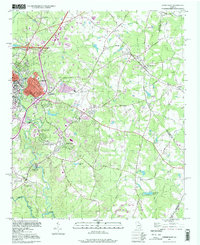 1998 Athens East1999 Print · USGSThe eastern edges of the University of Georgia and the surrounding Clarke County countryside appear here just before the millennium. Genealogists and local historians can trace the old rail lines of the Georgia railroad and locate rural landmarks like Winterville, Whitehall, and the Oconee Hill Cemetery.
 - 1998 Map of Athens West, 1999 Print
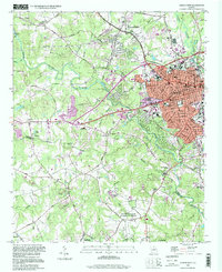 1998 Athens West1999 Print · USGSIn the late nineties, the western outskirts of Athens and Watkinsville showcase a landscape where academic and naval facilities meet traditional Georgia riverlands. Researchers can trace the Georgia Railroad and locate local landmarks like the Athens Speedway or Chestnut Grove Ch.
End of results
Showing maps 1-2 of 2
Top cities near Athens
- Jefferson historical maps
- Watkinsville historical maps
- Statham historical maps
- Arcade historical maps
- Nicholson historical maps
- Winterville historical maps
See more
Top neighborhoods of Athens
- Camelot historical maps
- Homewood Hills historical maps
- Elder historical maps
- Chatham Park historical maps
- Jefferson Valley historical maps
- Northridge Park historical maps
See more
Frequently asked questions
- What are the different types of historical maps available for Athens?
- What is the oldest map of Athens?
- Where can I purchase historical maps of Athens for my home or office?
- Where can I download high-res historical maps of Athens?
- Are there historical topographic maps available for Athens?
- Is there historical aerial imagery available for Athens?
- Where are historical maps of Athens sourced from?