1970s Maps of Brooklet, Georgia
Explore 2 historic maps of Brooklet from the 1970s. These maps offer a rare glimpse into what life looked like during the 1970s — showing old roads, neighborhoods, homes, and landmarks that have changed or disappeared over time.
Whether you're researching your family's past, planning a metal detecting trip, or studying how Brooklet's landscape evolved across the 1970s, these high-resolution maps are a powerful tool for exploring the history of this region.
- Focus on a specific era: All maps on this page are from the 1970s, giving you a focused view of this time period.
- See what’s changed: Compare century-old streets, trails, and buildings to today's modern landscape using overlays and satellite layers.
- Research with precision: Use these maps for genealogy, historical research, land use analysis, or educational projects.
- View, download, or print: Maps are fully viewable online in high resolution, and can be downloaded or printed for your own records.
Start exploring Brooklet's history through authentic maps from the 1970s. This is your window into the past.
Brooklet, GA maps
(2)- 1978 Map of Brooklet
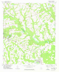 1978 Brooklet1978 Print · USGSBulloch County during the late seventies shows the expansion of Statesboro and the rural character of Brooklet. Researchers can trace old family names and community centers through sites like Bethlehem Ch, Grimshaw, and the Old Railroad Grade.
 - 1978 Map of Denmark
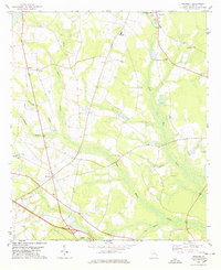 1978 Denmark1978 Print · USGSBulloch County's rural landscape is captured here in the late 1970s, showing a well-established network of farm roads and small communities. Genealogists can trace family connections through numerous landmarks like Emit Grove Ch, Denmark, and Harville Ch.
End of results
Showing maps 1-2 of 2
Top cities near Brooklet
- Statesboro historical maps
- Pembroke historical maps
- Newington historical maps
- Oliver historical maps
- Register historical maps
Frequently asked questions
- What are the different types of historical maps available for Brooklet?
- What is the oldest map of Brooklet?
- Where can I purchase historical maps of Brooklet for my home or office?
- Where can I download high-res historical maps of Brooklet?
- Are there historical topographic maps available for Brooklet?
- Is there historical aerial imagery available for Brooklet?
- Where are historical maps of Brooklet sourced from?