1970s Maps of Camden County, Georgia
Explore 20 historic maps of Camden County from the 1970s. These maps offer a rare glimpse into what life looked like during the 1970s — showing old roads, neighborhoods, homes, and landmarks that have changed or disappeared over time.
Whether you're researching your family's past, planning a metal detecting trip, or studying how Camden County's landscape evolved across the 1970s, these high-resolution maps are a powerful tool for exploring the history of this region.
- Focus on a specific era: All maps on this page are from the 1970s, giving you a focused view of this time period.
- See what’s changed: Compare century-old streets, trails, and buildings to today's modern landscape using overlays and satellite layers.
- Research with precision: Use these maps for genealogy, historical research, land use analysis, or educational projects.
- View, download, or print: Maps are fully viewable online in high resolution, and can be downloaded or printed for your own records.
Start exploring Camden County's history through authentic maps from the 1970s. This is your window into the past.
Camden County, GA maps
(20)- 1970 Map of Kings Ferry, 1973 Print
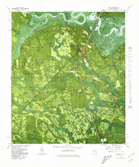
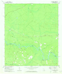 1970 Kings Ferry1973 Print · USGSThe Georgia-Florida borderlands along the St Marys River are documented here during the early 1970s. Local historians and genealogists can locate several riverfront landings and country churches, including Blood Landing, Kings Ferry, and Mt Olive Ch.3 unique versions available
 - 1970 Map of Boulogne, 1973 Print
 1970 Boulogne1973 Print · USGSThe Georgia-Florida border comes alive in the early seventies as the St Marys River winds through the wetlands of Camden and Nassau counties. Genealogists and local historians can trace the rail-side growth of Folkston and Boulogne, or locate the Camp Pinckney Ch and Bethune Middle Sch.3 unique versions available
 - 1975 Map of Tarboro, 1987 Print
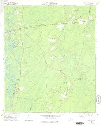
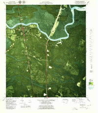
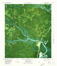
 1975 Tarboro1987 Print · USGSIn the Georgia lowcountry during the mid-seventies, the community of Tarboro sat at the heart of a wetland landscape. Researchers can trace rural lineages at Bickley Chapel Cem and Harrell Cem, or follow the path of the Old Railroad Grade.
 - 1975 Map of Waynesville, 1987 Print
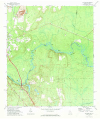
 1975 Waynesville1987 Print · USGSCoastal Georgia's riverine landscape is captured here in the 1970s, showcasing the winding Satilla River and the settlements of Waynesville and Atkinson. Genealogists can locate family-named sites like Linda Plantation, Ammons Cem, and Wiggins Cem among the swampy lowlands.
 - 1978 Map of Burnt Fort
 1978 Burnt Fort1978 Print · USGSCoastal Georgia's river-bottom lands are captured here in the late seventies as the river dictated the pace of local life. Researchers can trace historic river crossings and rural landmarks like Allens Ferry, Hopkins Bridge, and the Antioch Cem.2 unique versions available
 - 1978 Map of Waynesville
 1978 Waynesville1978 Print · USGSCoastal Georgia in the late 1970s reveals a landscape of river-fed swamps and old rail corridors. Genealogists can trace family names through numerous burial sites like Highsmith Cem or locate historic crossings at Ammons Ferry and Atkinson.
 - 1978 Map of Jerusalem
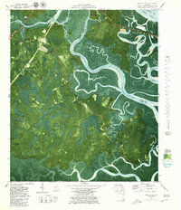
 1978 Jerusalem1978 Print · USGSCoastal Georgia's river-dependent landscape comes into focus during the late 1970s as the Satilla River winds toward the Atlantic. Genealogists and historians can trace family-named sites like Jim Baileys Mill, Clarks Bluff, and the community of Jerusalem.2 unique versions available
 - 1978 Map of Boons Lake
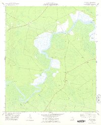
 1978 Boons Lake1978 Print · USGSThe Satilla River's complex oxbows and the expansive Big Bay wetlands defined this rural landscape in the late seventies. Family historians can trace local landmarks like Bethlehem Cem or the settlements at Big Oak and Lime Rock.2 unique versions available
 - 1978 Map of Tarboro
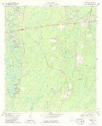
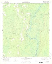
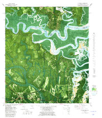
 1978 Tarboro1978 Print · USGSCamden and Brantley Counties are shown in the late 1970s as a landscape of rural churches and extensive wetlands. Genealogists and local historians can trace family-named sites like Harrell Cem and Providence Ch along the Old Railroad Grade.
 - 1978 Map of Brunswick
 1978 Brunswick1978 Print · USGSThe Georgia coast and its barrier islands are captured in the late 1970s, as I-95 and the rail lines shaped the growth of coastal towns. Genealogists and historians can trace family locations across the islands or locate sites near Fort Stewart, Darien, and Ludowici.2 unique versions available
 - 1979 Map of Woodbine
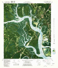
 1979 Woodbine1979 Print · USGSCoastal Camden County is captured in the late seventies as modern infrastructure began to bisect the ancient river swamps. Genealogists and historians can trace family landmarks and rural communities from Billyville to Colesburg, including Woodbine Cem and Gethsemane Ch.2 unique versions available
 - 1979 Map of Jekyll Island, 1980 Print
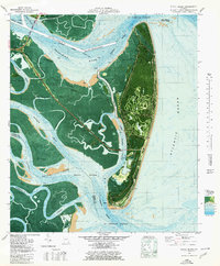 1979 Jekyll Island1980 Print · USGSJekyll Island at the close of the seventies reveals a coastal landscape transitioning from its historic roots to a modern state park. Trace family history or local landmarks like the Ruins of Georgias First Brewery, the Jekyll Island Airport, and Cedar Hammock.
 - 1979 Map of Brunswick West, 1980 Print
 1979 Brunswick West1980 Print · USGSCoastal Glynn County in the late seventies is defined by the heavy industry of the Brunswick waterfront and the winding tidal creeks of the western marshes. Genealogists and researchers can trace local congregations like Galilee Ch or follow the rails from Southern Junction across the Seaboard Coast Line.2 unique versions available
 - 1979 Map of St. Marys, 1980 Print
 1979 St. Marys1980 Print · USGSThe Georgia-Florida border comes alive in the late seventies as the tidal marshlands meet the growing grid of St. Marys. Researchers can trace old family settlements and local landmarks like Oak Grove Cem, Chester, and the Seaboard Coast Line.2 unique versions available
 - 1979 Map of Dover Bluff, 1980 Print
 1979 Dover Bluff1980 Print · USGSThe Georgia coast near Dover Bluff comes into focus in the late 1970s, showing the intricate tidal marshlands of COLONELS ISLAND. Researchers can pinpoint the Old Spanish Mission Ruins and trace family roots through sites like Hull Cem and Ella Park Ch.2 unique versions available
 - 1979 Map of Cumberland Island North, 1980 Print
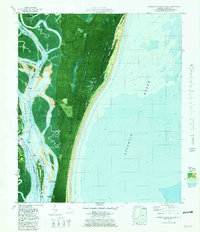
 1979 Cumberland Island North1980 Print · USGSThe northern reaches of Georgia's barrier islands are captured in the late seventies, showing the meeting of maritime forest and tide. Genealogists and researchers can locate Cumberland Wharf, an ancient Indian Mound, and family-named bluffs like Stockwell Bluff.
 - 1979 Map of Gross, 1980 Print
 1979 Gross1980 Print · USGSNassau County, Florida, sits at the Georgia border in the late seventies, where the St Marys River winds through a landscape of timber and swamp. Genealogists can locate small rural centers like Evergreen and Gross, alongside old landmarks like St James Ch and the Seaboard Coast Line railway.
 - 1979 Map of Kingsland NE, 1980 Print
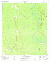
 1979 Kingsland NE1980 Print · USGSCamden County's intricate coastal marshes and river reaches are captured here in the late seventies. Genealogists and local historians can trace the geography around Fairfield Cem, the Forestview settlement, and landings like Cabin Bluff.
 - 1979 Map of Waverly, 1980 Print
 1979 Waverly1980 Print · USGSCoastal Camden County is captured in the late seventies as modern infrastructure began to bisect the ancient river necks. Genealogists and historians can trace family locations near Waverly, Horse Stamp Ch, and the well-preserved Quarterman Cem.2 unique versions available
 - 1979 Map of Cumberland Island South, 1981 Print
 1979 Cumberland Island South1981 Print · USGSCumberland Island and the Georgia coast are seen here in the late seventies as the National Seashore was being established. Trace the island's transition from private estates to public land through sites like Greyfield, Stafford, and the Landing Strip.2 unique versions available
End of results
Showing maps 1-20 of 20
Top cities of Camden County
- St. Marys historical maps
- Kingsland historical maps
- Kings Bay Base historical maps
- Woodbine historical maps
Frequently asked questions
- What are the different types of historical maps available for Camden County?
- What is the oldest map of Camden County?
- Where can I purchase historical maps of Camden County for my home or office?
- Where can I download high-res historical maps of Camden County?
- Are there historical topographic maps available for Camden County?
- Is there historical aerial imagery available for Camden County?
- Where are historical maps of Camden County sourced from?