1990s Maps of Camden County, Georgia
Explore 20 historic maps of Camden County from the 1990s. These maps offer a rare glimpse into what life looked like during the 1990s — showing old roads, neighborhoods, homes, and landmarks that have changed or disappeared over time.
Whether you're researching your family's past, planning a metal detecting trip, or studying how Camden County's landscape evolved across the 1990s, these high-resolution maps are a powerful tool for exploring the history of this region.
- Focus on a specific era: All maps on this page are from the 1990s, giving you a focused view of this time period.
- See what’s changed: Compare century-old streets, trails, and buildings to today's modern landscape using overlays and satellite layers.
- Research with precision: Use these maps for genealogy, historical research, land use analysis, or educational projects.
- View, download, or print: Maps are fully viewable online in high resolution, and can be downloaded or printed for your own records.
Start exploring Camden County's history through authentic maps from the 1990s. This is your window into the past.
Camden County, GA maps
(20)- 1993 Map of Cumberland Island North, 1995 Print
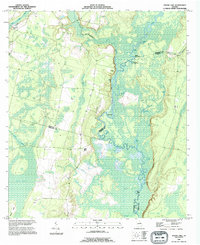
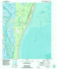
 1993 Cumberland Island North1995 Print · USGSThe northern reaches of Georgia's barrier islands appear in the early 1990s as a complex landscape of tidal rivers and maritime history. Researchers can trace landforms and heritage sites like the Little Cumberland Island Lighthouse, the First African Ch, and the Cumberland Cem.
 - 1993 Map of St Marys, 1995 Print
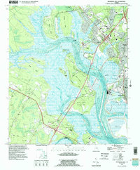
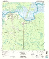
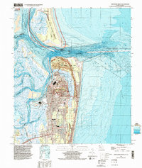
 1993 St Marys1995 Print · USGSThe coastal borderlands of Georgia and Florida come alive in the mid-nineties, centered on the historic riverfront of St Marys. Genealogists and local historians can trace family sites like Oak Grove Cem, Green Pine Cem, and the rural settlement at Chester.2 unique versions available
 - 1993 Map of Dover Bluff, 1995 Print
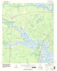
 1993 Dover Bluff1995 Print · USGSCamden County's coastal marshes and river networks are captured here in the mid-nineties, showing the complex interface of the Satilla River and the Atlantic. Genealogists can locate several local landmarks like Mt Sinai Ch, Whitehead Cem, and the Ruins of Old Spanish Mission.
 - 1993 Map of Burnt Fort, 1995 Print
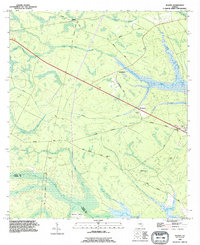
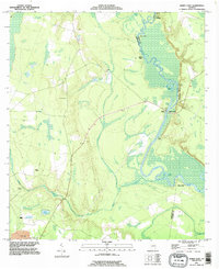 1993 Burnt Fort1995 Print · USGSThe Satilla River serves as the central artery for this Charlton and Camden County borderland in the 1990s. Researchers can trace riverfront heritage at Allens Ferry, Burnt Fort, and O'Berry Cem along the winding wetlands.
 - 1993 Map of Gross, 1995 Print
 1993 Gross1995 Print · USGSNassau County's border with Georgia is defined by the winding course of the St Marys River in the early nineties. Genealogists and local historians can trace family roots through landmarks like Wildes Cem, By Faith Ch, and the community of Becker.2 unique versions available
 - 1993 Map of Brunswick West, 1995 Print
 1993 Brunswick West1995 Print · USGSThe coastal marshes west of Brunswick are revealed in the early nineties, documenting the shifting intersection of industry and the Atlantic shoreline. Genealogists can trace local roots through landmarks like Lipthratt Cem, Southern Junction, and Emanuel Ch.
 - 1993 Map of Jekyll Island, 1995 Print
 1993 Jekyll Island1995 Print · USGSJekyll Island is shown in the early nineties as a fully realized state park and maritime retreat. Genealogists and local historians can locate the Du Bignon Cem and Jekyll Chapel, or trace coastal changes near Jekyll Pt and St Andrew Sound.
 - 1993 Map of Boons Lake, 1995 Print
 1993 Boons Lake1995 Print · USGSIn the mid-1990s, the riverine borderlands of Brantley and Camden counties remained a landscape of dense swamps and winding waterways. Genealogists and local historians can locate remote landmarks like Bethlehem Cem or trace the oxbows of Boons Lake and Upper Hog Pen.
 - 1993 Map of Jerusalem, 1995 Print
 1993 Jerusalem1995 Print · USGSCoastal Camden County in the early nineties is defined by the winding Satilla River and its intricate network of island landings. Genealogists and local historians can trace the sites of Jim Baileys Mill, Owens Ferry, and Tompkins Cem.
 - 1993 Map of Woodbine, 1995 Print
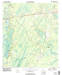
 1993 Woodbine1995 Print · USGSCoastal Camden County is defined by the winding Satilla River and its vast marshlands during the 1990s. Local researchers can trace family roots through several landmarks including Hamilton Chapel, Woodbine Cem, and the historic settlement at Ceylon.
 - 1993 Map of Waverly, 1995 Print
 1993 Waverly1995 Print · USGSCoastal Camden County is seen here in the mid-1990s, where the Little Satilla River meets a network of wetlands and small communities. Genealogists and historians can locate rural landmarks like Mt Oran Ch, Quarterman Cem, and the historic Spring Bluff landing.
 - 1993 Map of Bladen, 1995 Print
 1993 Bladen1995 Print · USGSCoastal Georgia's riverine lowlands come into focus in the early nineties, showing a landscape of tidal swamps and rural junctions. Genealogists can trace family names at the Higginbotham Cemetery and Wright Cemetery, or locate community hubs like New Zion Church.
 - 1993 Map of Kingsland, 1995 Print
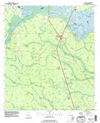
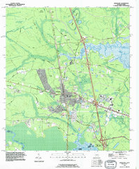 1993 Kingsland1995 Print · USGSKingsland and the Georgia-Florida border are captured here in the early nineties as modern infrastructure began to reshape the old river landscapes. Genealogists and local historians can trace rural roots through Evergreen Cem, the St Marys Railroad, and the community at Kinlaw.
 - 1993 Map of Waynesville, 1995 Print
 1993 Waynesville1995 Print · USGSBrantley County in the early nineties shows a landscape deeply tied to the Satilla River and its intricate swamp systems. Genealogists and local historians can locate many rural burial sites, including Jackson Cem and Daniels Cem, alongside old routes like Old Jacksonville Road.
 - 1993 Map of Kingsland NE, 1995 Print
 1993 Kingsland NE1995 Print · USGSCoastal Georgia's intricate river systems and marshlands are captured here in the early nineties, showing the landscape of Camden County. Researchers can trace rural settlements like Forestview or locate family burial sites at Fairfield Cem and Floyd Cem.
 - 1993 Map of Tarboro, 1995 Print
 1993 Tarboro1995 Print · USGSCoastal Georgia's marshy interior near the Brantley County line is captured in the mid-nineties, showing a landscape defined by tidal creeks and deep wetlands. Genealogists and local historians can trace the Harrell Cem, the settlement of Tarboro, and the path of an Old Railroad Grade.
 - 1994 Map of Cumberland Island South, 1995 Print
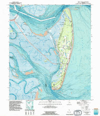
 1994 Cumberland Island South1995 Print · USGSThe Georgia coastline near Camden County is shown in the mid-1990s as it transitions from historic island estates to military strategic zones. Local historians can trace the grounds of Greyfield, identify the Carnegie Cem, and locate the Kings Bay Naval Submarine Base.2 unique versions available
 - 1994 Map of Harrietts Bluff, 1995 Print
 1994 Harrietts Bluff1995 Print · USGSCamden County's coastal landscape is captured in the mid-nineties as the naval presence at Kings Bay expanded alongside historic riverside settlements. Researchers can locate family landmarks like Scotchville and Harrietts Bluff or trace the John H Mcintosh Sugar Mill Site Ruins.
 - 1994 Map of Fernandina Beach, 2002 Print
 1994 Fernandina Beach2002 Print · USGSAmelia Island and the Georgia-Florida border are captured here in the mid-nineties, showing the intersection of coastal history and modern infrastructure. Genealogists and historians can locate Old Fernandina, Bosque Bello Cem, and schools like Southside Sch.
 - 1998 Map of Cumberland Island North, 2001 Print
 1998 Cumberland Island North2001 Print · USGSThe northern reaches of the Georgia barrier islands are captured here in the late nineties, showcasing the intersection of wild coast and isolated settlement. Researchers can trace the heritage of local communities through sites like First African Ch, Cumberland Cem, and the Little Cumberland Island Light (Abandoned).
End of results
Showing maps 1-20 of 20
Top cities of Camden County
- St. Marys historical maps
- Kingsland historical maps
- Kings Bay Base historical maps
- Woodbine historical maps
Frequently asked questions
- What are the different types of historical maps available for Camden County?
- What is the oldest map of Camden County?
- Where can I purchase historical maps of Camden County for my home or office?
- Where can I download high-res historical maps of Camden County?
- Are there historical topographic maps available for Camden County?
- Is there historical aerial imagery available for Camden County?
- Where are historical maps of Camden County sourced from?