1930s Maps of Camden County, Georgia
Explore 2 historic maps of Camden County from the 1930s. These maps offer a rare glimpse into what life looked like during the 1930s — showing old roads, neighborhoods, homes, and landmarks that have changed or disappeared over time.
Whether you're researching your family's past, planning a metal detecting trip, or studying how Camden County's landscape evolved across the 1930s, these high-resolution maps are a powerful tool for exploring the history of this region.
- Focus on a specific era: All maps on this page are from the 1930s, giving you a focused view of this time period.
- See what’s changed: Compare century-old streets, trails, and buildings to today's modern landscape using overlays and satellite layers.
- Research with precision: Use these maps for genealogy, historical research, land use analysis, or educational projects.
- View, download, or print: Maps are fully viewable online in high resolution, and can be downloaded or printed for your own records.
Start exploring Camden County's history through authentic maps from the 1930s. This is your window into the past.
Camden County, GA maps
(2)- 1930 Map of Cumberland Island
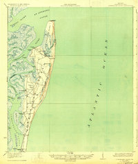 1930 Cumberland Island1930 Print · USGSCoastal Camden County during the interwar years is defined by the private estates and tidal marshes of this barrier island. Trace the early estate culture through Greyfield and the numerous landings like Stafford Wharf and the Lighthouse (Abandoned).3 unique versions available
 - 1939 Map of Bladen
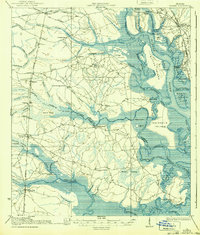 1939 Bladen1939 Print · USGSCoastal Glynn and Camden counties in the late 1930s reveal a landscape of intricate tidal marshes and emerging rail hubs. Genealogists and historians can trace the foundations of local life through the Waverly settlement, the Waverly Tramroad, and rural landmarks like the Magnolia School.2 unique versions available
End of results
Showing maps 1-2 of 2
Top cities of Camden County
- St. Marys historical maps
- Kingsland historical maps
- Kings Bay Base historical maps
- Woodbine historical maps
Frequently asked questions
- What are the different types of historical maps available for Camden County?
- What is the oldest map of Camden County?
- Where can I purchase historical maps of Camden County for my home or office?
- Where can I download high-res historical maps of Camden County?
- Are there historical topographic maps available for Camden County?
- Is there historical aerial imagery available for Camden County?
- Where are historical maps of Camden County sourced from?